Tag:tourism=picnic_site
 |
| Description |
|---|
| A locality that is suitable for outdoors eating, with facilities to aid a picnic such as tables and benches. |
| Rendering in OSM Carto |
| Rendering in OSM Carto |

|
| Group: tourism |
| Used on these elements |
| Useful combination |
|
| See also |
|
| Status: de facto |
| Tools for this tag |
|
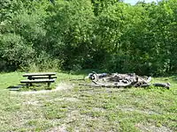
A picnic site is a place suitable for eating outdoors and may have additional facilities to have a picnic: toilets, water tap, BBQ, benches, table with benches and covered pavilions for bad weather.
How to map
Set a node ![]() or draw as an area
or draw as an area ![]() along the feature. Add the tag
along the feature. Add the tag tourism=.
Tags used in combination
These tags are properties which describe the availability of features (to be used with the values yes or no):
LOADING TAG LIST...
Additional features
Where these additional features are present they can be mapped, preferably as separate nodes ![]() or areas
or areas ![]() at the appropriate location:
at the appropriate location:
LOADING TAG LIST...