Tag:man_made=breakwater
 |
| Description |
|---|
| A man-made structure designed to protect a shore or harbour from the sea and waves. |
| Rendering in OSM Carto |

|
| Rendering in OSM Carto |

|
| Group: man made |
| Used on these elements |
| Status: de facto |
| Tools for this tag |
|
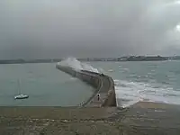
Use man_made= to identify breakwaters - man-made structures designed to protect a harbour or section of shore from the sea and waves, often to protect boats in a harbour from the effects of high waves. These may be built using loose large natural boulders, concrete tetrapods, demolition debris or as a solid concrete structure or solid stone structure. They are commonly large enough to have a flat top and may carry a publicly accessible highway=footway or track.
Take care not to confuse these with with man_made=groyne, which are commonly thin structures that are meant to stop loose materials (eg sand) being washed away or moved along the shore or man_made=piers, which are commonly platforms that extend out over water by use of pillars, or by floating primarily used for people to access boats or similar.
How to map
- For narrow breakwaters draw a linear way
 and add
 man_made=. - For wider breakwaters create a closed area
 and add
 man_made=andarea=yes.
material=stone- if the breakwater is made of stone
Example
| Tagging | OSM Carto | Foto |
|---|---|---|
man_made=
|
|
Objects that are used in this context
Breakwaters may also carry man_made=lighthouses or navigation lights. If there is a path along it use highway=footway or similar. If there is a wall along one side of a wider breakwater tag it with barrier=wall. Use mooring=* if boats can tie up alongside and highway=steps for steps leading down to the water.
See also
man_made=groyne- Coastline
- Breakwaters on Wikipedia