Tag:man_made=groyne
 |
| Description |
|---|
| A rigid structure built from a shoreline or riverbank that interrupts water flow and limits the movement of sediment. |
| Rendering in OSM Carto |

|
| Rendering in OSM Carto |

|
| Group: man made |
| Used on these elements |
| Status: de facto |
| Tools for this tag |
|
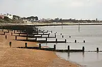
Use the man_made= tag to mark a groyne (spelled groin in American English), which is a rigid structure stretching out a short distance from the shoreline or riverbank for the purpose of reducing the movement of sediment (eg sand and gravel) or sometimes to reduce ice-jamming.
Not to be confused with man_made=breakwater, which is used for structures designed primarily to create an area of calm water for mooring boats, or with man_made=pier, which is used for structures on which people walk over water to access boats or similar.
Another name for this structure is wing dam.
How to map
Create a linear way ![]() along the length of the groyne and add
along the length of the groyne and add
Tags used in combination
material=*- Material from which the groyne is madetidal=yes- for the parts submerged on high tide and above water on low tide.
Very wide groynes (such as way 373881874) can be mapped as areas ![]() by adding
by adding man_made= and area=yes.
Examples
Gallery
-
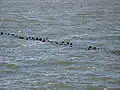 Groyne under water
 -
 Groyne at the beach
 -
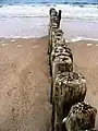
 Stone groyne
 -
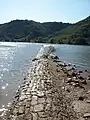
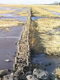 Groyne in the tidelands