Tag:natural=cape
 |
| Description |
|---|
| A piece of elevated land sticking out into the sea or large lake. |
| Group: natural |
| Used on these elements |
| Useful combination |
|
| See also |
| Status: de facto |
| Tools for this tag |
|
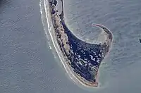
![]() Cape - a prominent piece of land sticking out into the sea or large lake. From the water side these tend to be points to circumnavigate and often serve as landmarks for orientation, from the land side capes are geographic extreme points sticking furthest out into the sea or a lake into a certain direction. This definition includes capes, heads, headlands and (water) promontories.
Cape - a prominent piece of land sticking out into the sea or large lake. From the water side these tend to be points to circumnavigate and often serve as landmarks for orientation, from the land side capes are geographic extreme points sticking furthest out into the sea or a lake into a certain direction. This definition includes capes, heads, headlands and (water) promontories.
Sometimes natural= is interpreted to include a broader range of coastal land forms like peninsulas but as of October 2018 the overwhelming majority of capes mapped (>99%) refer to capes in the strict sense of coastal extreme points or prominent landmarks at the coast.
How to map
Add a node ![]() and tag with
and tag with natural= and name=*. Some mappers join the node to the coastline, others put it nearby.
Mapping caveats
This tag should not be used for:
- peaks near the coast - use
natural=peak. - cliffs near the coast - use
natural=cliff. - named sections of a coast in general - use
place=localityor tag the name on the coastline. - whole land areas extending into the water (usually called peninsulas) where the name applies to the whole area and not to a coastal extreme point or a prominent landmark at the coast - use
natural=peninsula. - (thin) land bridges that connect two larger land masses - use
natural=isthmus.