Tag:natural=gully
 |
| Description |
|---|
| Small scale cut in relief created by water erosion. |
| Group: natural |
| Used on these elements |
| Useful combination |
| See also |
| Status: in use |
| Tools for this tag |
|
Description
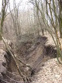
A gully is a small scale land form (a few to a few tens of meters) incised into surrounding terrain through erosion by flowing water. See ![]() gully on wikipedia for more information.
gully on wikipedia for more information.
Note: description in other languages give smaller maximum width recommendation. If the erosion area is large enough that it can be mapped in detail you can use natural=earth_bank instead.
How to map
Draw a way along the course of the gully from top to bottom.
Mapping caveats
This tag should not be used for:
- larger valleys or stable relief forms with no fresh signs of erosion - use
natural=valleyinstead. - man-made ditches - use
barrier=ditch - natural rock faces, cliffs or rocky slopes - use
natural=cliff - large steep relief edges due to larger scale erosion - use
natural=earth_bank - man-made embankments - use
man_made=embankment
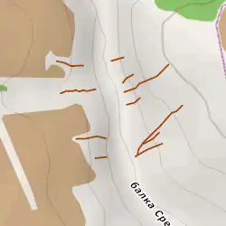
Rendering
natural= is not currently rendered in the OSM Carto style. The following figure shows an example of an illustration in Maperitive: