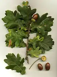
Tag:species=Quercus robur
 |
| Description |
|---|
| A pedunculate oak. |
| Rendering in OSM Carto |
| Group: natural |
| Used on these elements |
| Useful combination |
|
| See also |
| Status: in use |
| Tools for this tag |
|
This species tag identifies a pedunculate oak, the second most mapped species in OpenStreetMap.
How to map
Place a node ![]() at the location of the tree's trunk, then add the following tags:
at the location of the tree's trunk, then add the following tags:
Statistics
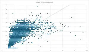
As of 19 May 2025[1]:
- the average height is 13.26 m, with the tallest tree reaching 48 m, based on 11074 trees[2].
- the average circumference is 1.83 m, with the thickest trees measuring up to 900 m, based on 49630 trees[3].
- the average height/circumference ratio is 15.07 (minimum: 0.03, maximum: 2400), based on 5879 trees.
See also
- Check and fix Quercus robur trees - MapRoulette challenge.