Tag:tourism=chalet
 |
| Description |
|---|
| A holiday cottage with self-contained cooking and bathroom facilities. |
| Rendering in OSM Carto |
| Group: tourism |
| Used on these elements |
| Useful combination |
| See also |
| Status: approved |
| Tools for this tag |
|
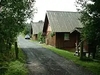
tourism= describes a ![]() holiday cottage, holiday home or vacation home with self-contained cooking and bathroom facilities.
holiday cottage, holiday home or vacation home with self-contained cooking and bathroom facilities.
For lack of better alternative, this tag is also applied for a group of chalets under the same operator. An attempted replacement tourism=holiday_village is rarely used.
Not to be confused with the French term ![]() chalet for privately owned mountain cabins, for them it is better to use
chalet for privately owned mountain cabins, for them it is better to use building=cabin or building=house instead.
Chalets are detached holiday cottages rented exclusively by a single guest groups, unlike tourism=apartment, which are several flats in one shared building.
How to map
For individual chalets, place a node at the center of the chalet or draw an area along its outline. Add tourism=.
Note that tourism= alone does not automatically cause the building to be rendered. Consider adding an appropriate building=* tag, such as cabin, hut, bungalow or, at minimum, yes.
For a group of chalets, place a node at its center or draw an area around it. Add tourism= and name=* of the group.
Tags used in combination
For individual chalets:
For holiday villages:
brand=*– the brand / association this chalet belongs to (possibly aclub=sport)operator=*– person, company or community responsible for the chalet (local operator)addr=*– the address of the chalet- Contact information:
- Internet access:
pets_allowed=*– if the chalet allows or not pets
See also
building=static_caravantourism=wilderness_huttourism=alpine_huttourism=guest_housetourism=apartmenttourism=camp_sitecabins=*