Tag:traffic_calming=island
 |
| Description |
|---|
| A traffic calming island is a structure for the purpose of slowing down traffic, temporarily separating two different traffic directions. |
| Group: highways |
| Used on these elements |
| See also |
| Status: de facto |
| Tools for this tag |
|
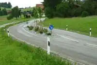
A traffic calming island is a structure for the purpose of slowing down traffic, separating at least two lanes of a highway for a short distance. The tag is a bit of a misnomer. Calming effects generally stem from other characteristics, such as a swerving lane (traffic_calming=chicane) and/or a reduction in per-lane width, where the island instead functions as a practical barrier and discourages/enforces drivers to not leave their lane. It follows from this that the tag would not be applicable for islands which are defined exclusively by road paint with no obstructions of any kinds (kerbs, trees, signposts, etc.).
The width of the island is usually under a few meters. The island doesn't necessarily have to have a right-of-way indicator. The area of the island itself can be drawn using area:highway=traffic_island, but the traffic calming feature is meant to be used as a point on the way itself, or tagged on part of the way.
Note that as of mid April 2023, only about 3% of pedestrian crossings with pedestrian refuges (crossing:island=yes or the deprecated crossing=island) are also tagged with traffic_calming=. So as a data consumer, if you are looking for all traffic islands, you should look for crossings with the tags mentioned, too.
How to map
For an island between two lanes of a carriageway, either:
- put a

traffic_calming=node on the road (especially if it's a small island), - split the carriageway into parallel lanes, marked
oneway=yesas appropriate, add thetraffic_calming=to the ways, and optionally draw the island itself as an area between them using
 area:highway=traffic_island.
Tags to use in combination
For traffic calming islands drawn as a node ![]() :
:
direction=*- if an island is made to only slow down traffic in one direction
For traffic islands drawn as an area ![]() using
using area:highway=traffic_island:
surface=*– Surface of the traffic island, e.g.asphalt,paving_stoneslanduse=grass– For traffic islands covered with grass (otherlanduse=*ornatural=*types may also occur, e.g.landuse=greeneryornatural=shrubbery)barrier=kerb+kerb=*– For solid traffic islands
Rendering
- One possible rendering may be as a small hollow dot in the middle of a node, or a small hollow line in the middle of a way. When creating software, these choices are yours.
- None, currently, by the osm-carto layer.
- iD and JOSM editors represents this tag with an icon: Example-object
- OsmAnd has a possibility to alert drivers of incoming
traffic_calming=*features, a warning icon with a speed bump is shown[1].
Possible tagging errors
See also
crossing:island=*– Specifies whether afootway=traffic_islandcrossing has a refuge islandhighway=mini_roundabout– A road junction where the traffic goes around a painted circle or traversable island and has right of way.traffic_calming=painted_island– An island painted on a road- Proposals:
area:highway=traffic_islandis mentioned in a 2011 inactive proposal.- The proposal
landuse=traffic_islandfor a pedestrian refuge on roads was abandoned.
Weblinks
- Traffic island on Wikipedia
References
- ↑ OsmAnd Docs - Alert types -https://osmand.net/docs/user/widgets/nav-widgets/#alert-types