Tag:waterway=drainage_channel
 |
| Description |
|---|
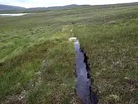
| A narrow and shallow drainage channel dug in peat, with active drainage flow in the spring to remove standing water on grass. |
| Group: waterways |
| Used on these elements |
| Useful combination |
|
| See also |
| Status: in use |
| Tools for this tag |
|
The tag waterway= has been used, as of December 2023, primarily by one mapper in one area of the Netherlands to mean the following:
- These are narrow and shallow drainage channels dug in peat, with active drainage flow in the spring to remove standing water on grass. Too small for
waterway=ditch. Typical of Dutch and UK peat and moor areas. See http://www.geograph.org.uk/photo/4599553
Notes
- In a community forum discussion most people agreed that it was fine to use the tag
waterway=ditchfor this type of waterway. - As of December 2023, there are ongoing discussions about the relationship between
waterway=drain,waterway=ditchand the best way to tag very small and minor drains. See for example this community forum discussion and this one. - The tag
seasonal=yeswas used in addition. See alsointermittent=*and the section there on intermittent vs. seasonal.