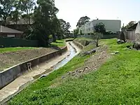
Tag:waterway=drain
 |
| Description |
|---|
| An artificial free flow waterway used for carrying superfluous water, usually lined with concrete. |
| Rendering in OSM Carto |

|
| Group: waterways |
| Used on these elements |
| Useful combination |
|
| See also |
| Status: de facto |
| Tools for this tag |
|
Use waterway= for artificial waterways, typically lined with concrete or similar, used to carry superfluous water like storm water or grey-discharge.
See also waterway=ditch for simpler non-lined artificial drainage ditches.
For artificial waterways created for carrying useful water or for transport consider using waterway=canal.
How to map
Create a linear way in the direction of flow, connecting the ends appropriately to other waterway elements to create a routable network. If a flow exists (or it could exist), the direction of the way must be downstream (i.e. the way direction follows the flow). If the drain discharges into another drain, stream, a river, or other waterway or into the ocean, sea, or similar you should make sure both are connected through a shared node. Add
Tags used in combination
name=*operator=*width=*tunnel=culvertandlayer=*for sections where the ditch runs in a culvert (pipe/culvert) under roads, paths, railway lines, etc.intermittent=*
Water covered area
Ditches that are wider should be drawn with natural=water + water=drain as an area ![]() (in addition to the main flow
(in addition to the main flow waterway=) so that they are rendered cleanly.
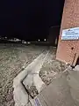
Photos
See also
waterway=ditch- An small artificial free flow waterway used for carrying superfluous water for drainage purposes, usually unlined.waterway=spillwayman_made=manhole+manhole=drain+inlet=grate- drain grate used to catch storm rain water