Tag:waterway=lock_gate
 |
| Description |
|---|
| A gate of a lock |
| Rendering in OSM Carto |
| Group: waterways |
| Used on these elements |
| Useful combination |
|
| Status: de facto |
| Tools for this tag |
|
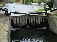
A gate of a ![]() lock. (A lock is a device used for raising and lowering boats, ships and other watercraft between stretches of water of different levels on river and canal waterways by raising and lowering the water level in a fixed chamber.)
lock. (A lock is a device used for raising and lowering boats, ships and other watercraft between stretches of water of different levels on river and canal waterways by raising and lowering the water level in a fixed chamber.)
How to map
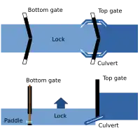
Simply add two nodes ![]() to the waterway at the points where the top/bottom gate is located and add the tag
to the waterway at the points where the top/bottom gate is located and add the tag waterway= to both of them. Direction of the waterway should be downstream (from top to bottom gate).
It is also possible to map the exact location of lock gate using a way ![]() .
.
The mapping of a lock and its components is described on the page lock=*.
Examples
| Picture/Description | Tags | OSM Carto |
|---|---|---|
|
two ways with the tag: |
All features of a lock
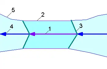
- 1. Lock
- Separate the way
 of the
 waterway=*at the two lock gates. Mark the newly created section with
- 3. Gate of a lock
-
- Draw the lock gate with a line and add
waterway=.
- Draw the lock gate with a line
Seamark tags
See also
barrier=coupure- a closable cut through a floodwall or a dykewaterway=sluice_gate- A movable gate to control water flowseamark:type=gate- Gate on a waterway (A structure that may be swung, drawn, or lowered to block an entrance or passageway.)lock=*- for the lock basin (Marks a stretch of waterway bounded by lock gates, forming a lock)- Seamarks/Gates