Tag:wetland=mangrove
 |
| Description |
|---|
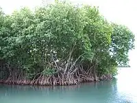
| Mangrove ecosystem is formed by forests of salt tolerant mangrove trees in the tidal zone of tropical coasts with water temperatures above 20 °C. |
| Rendering in OSM Carto |
|
| Group: natural |
| Used on these elements |
| Requires |
| Implies |
|
- |
| See also |
| Status: approved |
| Tools for this tag |
|
The ecosystem ![]() mangrove is formed by forests of salt tolerant mangrove trees in the tidal zone of tropical coasts with water temperatures above 20 °C.
mangrove is formed by forests of salt tolerant mangrove trees in the tidal zone of tropical coasts with water temperatures above 20 °C.
How to map
Draw the outline ![]() of the area and tag it with
of the area and tag it with natural=wetland + wetland=.
If there is a body of water or other land use within the area, this has to be treated as a Relation:multipolygon like an island.
If it is an island, and you want it to tag with natural=coastline, please draw a second line and add the tags natural=wetland + wetland=.