IT:Key:cycleway
 |
| Descrizione |
|---|
| Per descrivere le caratteristiche di una pista ciclabile. |
| Gruppo: Cycleways |
| Applicabile agli elementi |
| Implica |
| Vedi anche |
| Stato: de facto |
| Strumenti |
Descrizione
Il tag =* è usato per descrivere le caratteristiche specifiche di quelle piste ciclabili che si sviluppano accanto ad una strada, e sono contrassegnate da apposita segnaletica. Strada e pista ciclabile possono essere contrassegnate con un'unica via, che descrive l'andamento di entrambe. Tale via viene etichettata con highway=* avente il valore pertinente alla strada, cui si aggiunge la chiave =* che descrive la pista ciclabile.
Per descrivere piste ciclabili autonome, cioè non associabili ad una strada, si usa invece l'etichetta highway=cycleway.
Valori
Cycleway (piste ciclabili)
Il tag =* è usato per descrivere le piste ciclabili che si sviluppano su o accanto a una strada. Strada e pista ciclabile vengono disegnate con un'unica via, etichettata con i valori highway=* pertinente alla strada e =* pertinente alla pista ciclabile.
Per descrivere piste ciclabili autonome, cioè disegnate separatamente da una strada, si usa invece highway=cycleway.
| Valore | Elemento | Spiegazione | Foto | |||
|---|---|---|---|---|---|---|
Dedicated bicycle lanes | ||||||
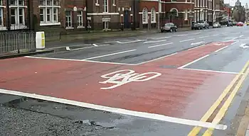
| lane | Corsia ciclabile (lane) ricavata all'interno della stessa carreggiata su cui scorrono mezzi motorizzati, contrassegnata da apposita segnaletica orizzontale (striscia di separazione). | _-_geograph.org.uk_-_4129897.jpg) | ||||
|
| ||||||
| shared_lane | I ciclisti condividono una corsia con i veicoli motorizzati, come indicato da apposita segnaletica. |  | ||||
| share_busway | Esiste una corsia per gli autobus, e le biciclette hanno il permesso di percorrerla. | 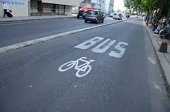 | ||||
Bicycle tracks | ||||||
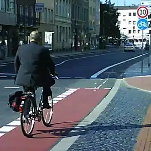
| track | Pista ciclabile fisicamente separata dalla strada. Può essere una carreggiata parallela al resto della strada, separata ad esempio mediante un cordolo, oppure una pista a sé stante che si sviluppa principalmente in prossimità della strada. In alternativa, è preferibile disegnare una via indipendente etichettata con highway=cycleway, stando attenti a disegnare tutte le interconnessioni tra la pista e la strada, in particolare agli incroci. |  | ||||
| separate | Should be used to indicate that a cycle track associated with a highway has been mapped as a separate OSM element (i.e., is tagged with highway=cycleway). Meaning is similar to the use of sidewalk=separate for footways, and can potentially be used when simplifying geometries for rendering. It also acts as a hint to avoid duplicating an existing cycleway by adding =track to a highway. Don't confuse with segregated=yes.
|
|||||
No bicycle infrastructure | ||||||
| no | Explicitly marks that a street has no bicycle infrastructure. This allows to explicitly note that the road was surveyed for bicycle infrastructure. | 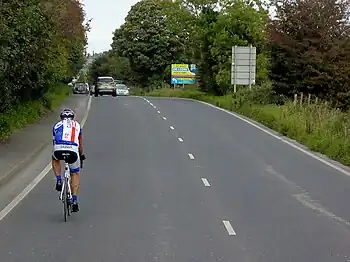 | ||||
Other bicycle infrastructure | ||||||
| crossing | Used on separately mapped paths to indicate that it's a bicycle crossing. | 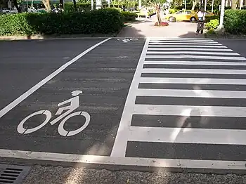 | ||||
| shoulder | Used to indicate that a road has no designated infrastructure for cyclists, but shoulders (a.k.a. breakdown lanes) are navigable and legal to cycle on. Especially on rural roads with high speed limits, the existence of a shoulder usable by cyclists can make the difference whether the road is usable at all (semi-)safely for cyclists. Not every shoulder=* is automatically usable for cyclists: Some shoulders are used for parking (parking=shoulder) instead, not all shoulders are paved (with asphalt, e.g. grass pavers). Additionally, shoulder=yes is typically only mapped for shoulders that are broad enough to accommodate a car. For cyclists however, a less wide shoulder is fine, too.
|
 | ||||
| link | A connector between OSM segments for cycle traffic, for example to connect a separately mapped cycle path to a junction on the opposite side. Serves primarily as a routing aid and does not necessarily have to be identifiable as built infrastructure. | 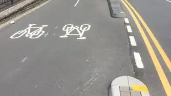 | ||||
| traffic_island | Used on the parts of refugee islands of a =crossing.
|
 | ||||
| asl | Indicates an advanced stop line or bike box at junctions. Use =asl on a direction=forward or direction=backward for an explicitly reference to the closest junction that a ASL relates to and thus the direction of traffic that it applies to.
|
 | ||||
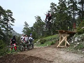
| gap_jump | A gap jump segment of MTB downhill route. Generally would consist of two or three parts: a take-off ramp; a physically non-existent mid-air segment; and optionally a landing ramp (if not present, a regular bike track serves as a landing zone). The mid-air segment may cross other roads or features, in which case it should be tagged with layer=1 without a node at the intersection; surface=none has occasionally been added as well. Consider explicitly providing foot=no or access=no + bicycle=designated in order to prevent routing for any other activity.
|
 | ||||
Deprecated or discouraged tags | ||||||
| Indica che su una strada a senso unico, pur in assenza di una corsia dedicata, alle biciclette è permesso il transito anche in contromano (la strada è a senso unico eccetto che per le biciclette). | ||||||
| Su questa strada i ciclisti condividono lo spazio con traffico di altro tipo. | ||||||
This table is a wiki template with a default description in English. Editable here.
Nota: quando viene usato uno dei valori opposite, opposite_lane o opposite_track, potrebbe essere utile aggiungere anche il tag oneway:bicycle=no.
Al momento non esiste alcun metodo ufficiale per indicare se una pista ciclabile esiste solamente su un lato della strada. Una proposta è di utilizzare:
| Chiave | Valore |
|---|---|
| highway | <tipo di strada> |
| cycleway:left o cycleway:right | lane o opposite_lane |
Esempi
| Picture/Description | Tags | Mapnik | Osmarender |
|---|---|---|---|
Corsia Ciclabile su strada residenziale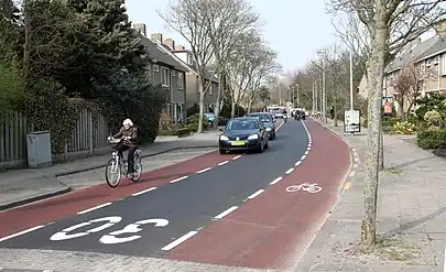
|
highway=residential =lane
|
--- | --- |
Pista (strada) ciclabile indipendente
|
highway=cyclewaybicycle=designated
|
--- | --- |
Pista ciclabile lungo una strada residenziale (stessa strada, carreggiata separata)
|
una sola via con: highway=residential=track
|
--- | --- |
Etichette suggerite per casi particolari
| |

|
highway=path foot=designated bicycle=designated segregated=yes
|
| |

|
highway=path foot=designated bicycle=designated segregated=no
|
Voci correlate |
|