JA:Tag:place=city_block
 |
| 説明 |
|---|
| 街区。名前がついた都市の区画で、ふつうは道路に囲まれています。 |
| グループ: 場所 |
| 適用できる要素 |
| よく併用されるタグ |
| 状態:使用中 |
| ツール |
place= タグは、町や市の中で name=* に対応する街区を識別するために使用します。
They should be mapped as a polygon drawn around a group of contiguous building plots, on the line where they meet the street. They are equivalent to 'manzanas' in Spanish (e.g. Barcelona and Buenos Aires), 'îlots' in French, 'bouwblokken' in Dutch (e.g. Amsterdam), and 'kvarter' ('fastigheter' sharing the same name) in Swedish.
At a simple level they can be thought of as islands of private developable plots surrounded by public highway - as such, they should not include pavements or sidewalks. However, it should be noted that city blocks can contain public amenity space (e.g. parks and playgrounds) and so the distinction is primarily between land used for buildings or amenity space, and land used for streets/highways.
In some cities they are given identifying code numbers or names which, where no boundary polygon has been drawn, 街区の中央にノードを配置することによって使用することも可能です。
タグの使用例
- スウェーデンのストックホルムで多く使われています。 overpass-turbo.eu のこのクエリで表示させることができます。
- Manzanas in Buenos Aires
- Bouwblokken in Amsterdam
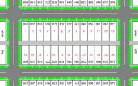
- マンハイム (https://en.wikipedia.org/wiki/Mannheim#Block_numbering_and_computer_mapping)
関連項目
- 街区(Wikipedia)
place=neighbourhood- A neighbourhood is a smaller, named, geographically localised place within a suburb of a larger cityplace=quarter- A quarter is a named, geographically localised place within a suburb of a larger city or within a town which is bigger than a neighbourhoodplace=suburb- A part of a town or city with a well-known name and often a distinct identity.place=townplace=cityplace=plotlanduse=residential