Week 1
(29 Dec. – 4 Jan.)
|

|
| English
|
WikiMedia Italia produced a 7 minute long OpenStreetMap video guide, which was recently presented by Simone Cortesi at the wikimedia Italia conference
|

|
|
Week 2
(5–11 Jan2025-01-05–Error: Invalid time.)
|

|
| English
|
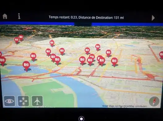
On Alaska Airlines, passengers can visualize the progress of their flight on their devices via Gogo WiFi inflight internet service
|
|
|
Week 3
(12–18 Jan2025-01-12–Error: Invalid time.)
|
|
| English
|
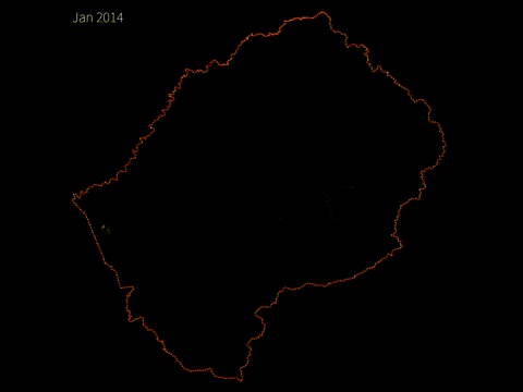
Animation showing the 2014 activity taking Lesotho from a blank spot on the map (approx 50k nodes) towards a full and rich set of map data. This work was completed in a large part by locals and government planners looking to utilise OpenStreetMap data as part of their workflow
|
|
|
Week 4
(19–25 Jan2025-01-19–Error: Invalid time.)
|
|
|
Week 5
(26 Jan – 1 Feb2025-01-26–Error: Invalid time.)
|
|
| English
|
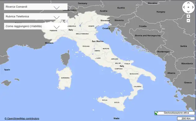
The website of the Italian gendarmerie (Carabinieri) now features as the only map, an OpenStreetMap map with a prominent copyright link. This is the first recorded use of a military force using OSM.
|
|
|
Week 6
(2–8 Feb2025-02-02–Error: Invalid time.)
|
|
| English
|
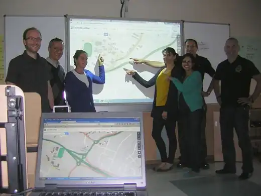
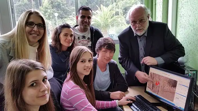
German and Ecuadorian teachers of Geography, History and IT proudly present the results of a mapping training session with JOSM. These teachers will pass on this training to other colleagues, and integrate some aspects of it into the curriculum to help Ecuadorean students improve their skills further.
|
|
|
Week 7
(9–15 Feb2025-02-09–Error: Invalid time.)
|
|
| English
|
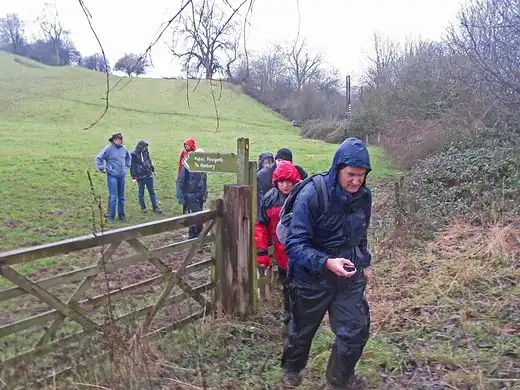
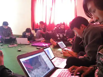
Local citizens from Bajrabarahi, Makwanpur, Nepal mapping their towns and villages. Kathmandu Living Labs, pioneer of OpenStreetMap in Nepal, was involved in training them. The training mostly focused on mapping agriculture and food security data
|
|
|
Week 8
(16–22 Feb2025-02-16–Error: Invalid time.)
|

|
|
Week 9
(23 Feb – 1 Mar2025-02-23–Error: Invalid time.)
|
|
| English
|
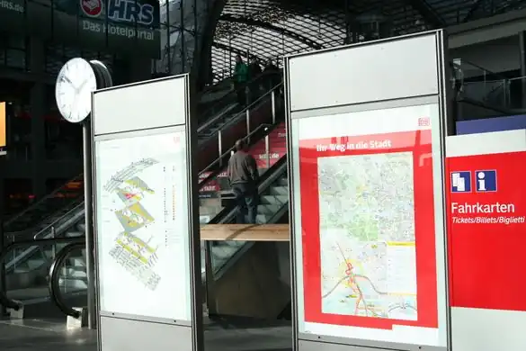
The main station in Berlin now has detailed OpenStreetMap maps of the city.
|
|
|
Week 10
(2–8 Mar2025-03-02–Error: Invalid time.)
|

|
| English
|
OpenStreetMap Lesotho members on Lesotho National TV show talking about #MapLesotho
|
|
|
Week 11
(9–15 Mar2025-03-09–Error: Invalid time.)
|

|
| English
|
Spectacular 3D-rendering of the Roman Theatre in Orange in France (map) made only from OpenStreetMap data mapped by Marcel Herault
|
|
|
Week 12
(16–22 Mar2025-03-16–Error: Invalid time.)
|

|
|
Week 13
(23–29 Mar2025-03-23–Error: Invalid time.)
|

|
|
Week 14
(30 Mar – 5 Apr2025-03-30–Error: Invalid time.)
|
|
|
Week 15
(6–12 Apr2025-04-06–Error: Invalid time.)
|
|
| English
|
Sorry, there was no image this week.
|
|
|
Week 16
(13–19 Apr2025-04-13–Error: Invalid time.)
|
|
|
Week 17
(20–26 Apr2025-04-20–Error: Invalid time.)
|

|
| English
|
The Scottish police use our maps to display different policing regions on their website, such as this Edinburgh region
|
|
|
Week 18
(27 Apr – 3 May2025-04-27–Error: Invalid time.)
|
|
|
Week 19
(4–10 May2025-05-04–Error: Invalid time.)
|
|
| English
|
Kathmandu Living Labs have mapped their city in detail over the past few years, which is now putting OpenStreetMap in a great position to provide maps for aid agencies responding to the Nepal earthquake. Here we see them working outdoors in case of aftershocks, as they coordinate with HOT on further mapping, and providing outputs for aid responders
|
|
|
Week 20
(11–17 May2025-05-11–Error: Invalid time.)
|
|
|
Week 21
(18–24 May2025-05-18–Error: Invalid time.)
|
|
| English
|
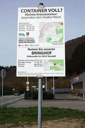
A signpost designed with maps from OpenStreetMap, showing the location of recycling bins in Werdohl, Germany
|
|
|
Week 22
(25–31 May2025-05-25–Error: Invalid time.)
|

|
| English
|
Another Mapzen 'Tangram' style, this time emulating a sketchy drawing effect. Browse the map (uses WebGL)
|
|
|
Week 23
(1–7 Jun2025-06-01–Error: Invalid time.)
|

|
|
Week 24
(8–14 Jun2025-06-08–Error: Invalid time.)
|

|
|
Week 25
(15–21 Jun2025-06-15–Error: Invalid time.)
|

|
| English
|
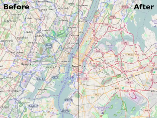
On 30th of May Maps.Me organized a "Mapping School" event in Moscow, where people were taught to survey a city block and map it in JOSM. Before and after image
|
|
|
Week 26
(22–28 Jun2025-06-22–Error: Invalid time.)
|

|
| English
|
Students from four countries came together for a Comenius school project MychOSM preparing field research on historical and geographical sites. This A0 print of OpenStreetMap was made using Mapwebbing
|
|
|
Week 27
(29 Jun – 5 Jul2025-06-29–Error: Invalid time.)
|
|
| English
|
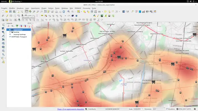
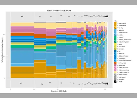
User:SK53 has been investigating retail POI data, looking at the stats by country, and plotting this in a variety of ways. Read more on his blog post. This "Marimekko" diagram shows different retail types (shop tags) in different European countries.
|
|
|
Week 28
(6–12 Jul2025-07-06–Error: Invalid time.)
|
|
|
Week 29
(13–19 Jul2025-07-13–Error: Invalid time.)
|

|
| English
|
Disneyland in California is celebrating its 60th anniversary this week. Kiosks, gardens and the routes of the roller-coasters, have all been mapped in glorious detail here on OpenStreetMap
|
|
|
Week 30
(20–26 Jul2025-07-20–Error: Invalid time.)
|

|
| English
|
This OpenStreetMap decorated wallet, manufactured by gerdkoch.de, was spotted on sale at the airport souvenirs shop in Bremen
|
|
|
Week 31
(27 Jul – 2 Aug2025-07-27–Error: Invalid time.)
|

|
| English
|
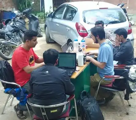
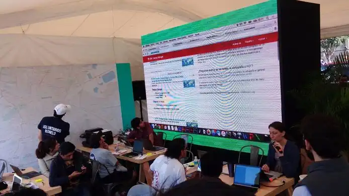
Participants of the first West African State Of The Map (SOTM)! Organized at the Campus Numérique Francophone (CNF) in Ouagadougou, Burkina Faso last week. 20 mappers from 7 sub-region countries joined (Bénin, Burkina Faso, Côte d'Ivoire, Mali, Niger, Sénégal, Togo), within the context of a capacity-building mission from the Projet Espace OpenStreetMap Francophone (Projet EOF). See the SOTMBF conference program
|
|
|
Week 32
(3–9 Aug2025-08-03–Error: Invalid time.)
|
|
| English
|
Air France have an interactive 3D globe map view on their seatback displays, with maps from OpenStreetMap!
|
|
|
Week 33
(10–16 Aug2025-08-10–Error: Invalid time.)
|

|
| English
|
The London Hack Weekend took place last weekend, with developers coming together to work on a wide variety of technical projects, as well as celebrating the OpenStreetMap birthday!
|
|
|
Week 34
(17–23 Aug2025-08-17–Error: Invalid time.)
|

|
|
Week 35
(24–30 Aug2025-08-24–Error: Invalid time.)
|

|
|
Week 36
(31 Aug – 6 Sep2025-08-31–Error: Invalid time.)
|

|
|
Week 37
(7–13 Sep2025-09-07–Error: Invalid time.)
|
|
|
Week 38
(14–20 Sep2025-09-14–Error: Invalid time.)
|
|
| English
|
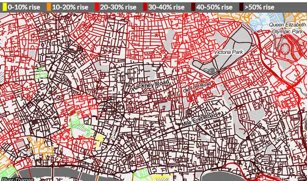
Transport campaigning website howcongestedismyroad.org.uk shows traffic modelling data from Transport For London, snapped onto OpenStreetMap road network data and overlaid over Stamen's black & white toner style base-map
|
|
|
Week 39
(21–27 Sep2025-09-21–Error: Invalid time.)
|

|
| English
|
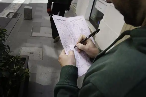
Volunteers verifying their position. The American Red Cross recently ran a community mapping exercise in Khayelitsha, a large township in Cape Town, South Africa. Read more on this diary entry including ways you can help with the ongoing mapping work
|
|
|
Week 40
(28 Sep – 4 Oct2025-09-28–Error: Invalid time.)
|

|
|
Week 41
(5–11 Oct2025-10-05–Error: Invalid time.)
|
|
|
Week 42
(12–18 Oct2025-10-12–Error: Invalid time.)
|

|
|
Week 43
(19–25 Oct2025-10-19–Error: Invalid time.)
|
|
| English
|
The Bangladesh OpenStreetMap community (facebook group) together with the Red Cross have been mapping the dense district of Gandaria in Dhaka
|
|
|
Week 44
(26 Oct – 1 Nov2025-10-26–Error: Invalid time.)
|

|
| English
|
Taking a flat map at the top, and bending it to form a street level 3D map at the bottom of the view. This effect is similar to the disturbing warped cityscapes in the movie 'Inception'. Here are two implementations running in the browser using tiled OpenStreetMap vector data with Tangram and with OSMBuildings. Read more on the googlemapsmania blog.
|
|
|
Week 45
(2–8 Nov2025-11-02–Error: Invalid time.)
|
|
| English
|
The 'standard' OpenStreetMap style was recently changed to represent major roads types with a steady progression of hue and lightness, helping to make them visible over other land types colour. Read more on the blog
|
|
|
Week 46
(9–15 Nov2025-11-09–Error: Invalid time.)
|

|
|
Week 47
(16–22 Nov2025-11-16–Error: Invalid time.)
|
|
|
Week 48
(23–29 Nov2025-11-23–Error: Invalid time.)
|

|
|
Week 49
(30 Nov – 6 Dec2025-11-30–Error: Invalid time.)
|
|
| English
|
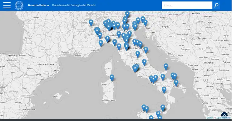
The map on this Italian government website shows trips made by Prime Minister Renzi. A simple but stylish Leaflet web map with black & white styled OpenStreetMap basemap by wikimedia Foundation
|
|
|
Week 50
(7–13 Dec2025-12-07–Error: Invalid time.)
|
|
| English
|
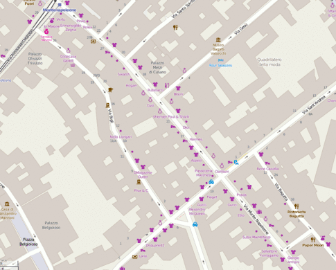
The stylish shopping boutiques of Via Monte Napoleone, Milan, now mapped out in lots of detail thanks to user:Alecs01
|
|
|
Week 51
(14–20 Dec2025-12-14–Error: Invalid time.)
|
|
| English
|
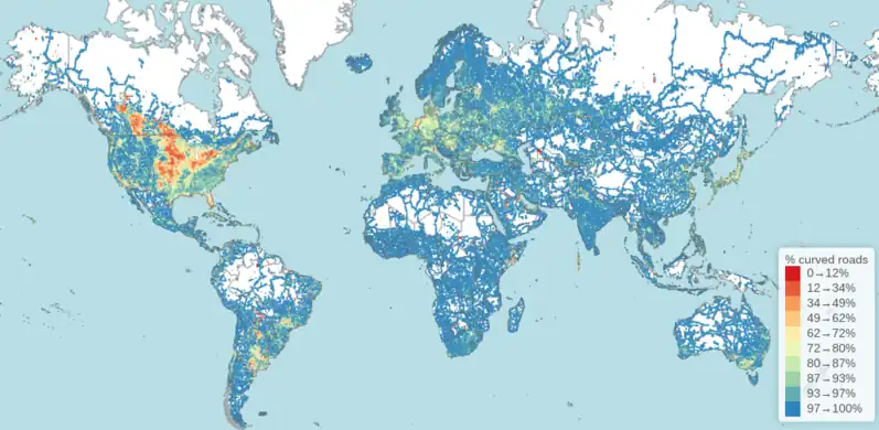
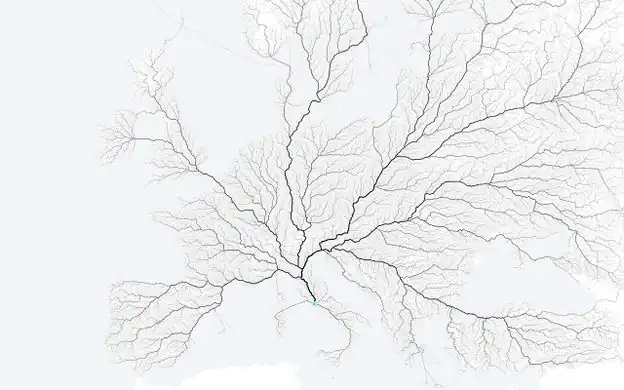
All roads lead to Rome. So the saying goes, and so this image illustrates. See this and other great OSM routing powered images on roadstorome.moovellab.com
|
|
|
Week 52
(21–27 Dec.)
|

|
|
Week 53
(28 Dec. – 3 Jan.)
|
|
|
