RU:Key:tidal
 |
| Описание |
|---|
| An area in the tidal range. |
| Группа: Море |
| Используется на элементах |
| Полезные сочетания |
| Смотри также |
|
| Статус: де-факто |
| Инструменты |
|
The tag =yes indicates that an element is in the tidal range. It could be a river, a shore, a part of a harbour or a water area.
When the part of the harbour has a gate which does not let the tide in you may tag it with =no. But this is the default value so it is not really necessary.
How to map?
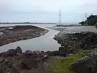
River
 River flow
waterway=river+name=*+=yes
 River's water body
natural=water+water=river+=yes
If you know where are the limits of the tide and of the river (because you have imagery at low tide and another at high tide), you can add 3 areas (closed ways or multipolygons), one for the river's water body and 2 (one on each side of the river) with tags natural=wetland + wetland=tidalflat (if these are muddy areas: you don't need in this case of tidal=yes) or natural=sand + =yes (if areas are sandy) or natural=shingle + =yes or any other tags (according to the type of soil) + =yes.
Tidal area at sea
Areas in the tidal range between ![]() mean high water springs (
mean high water springs (natural=coastline) and ![]() mean low water springs can be tagged with
mean low water springs can be tagged with =yes to explicitly indicate this.
- Foreshore rocks body
natural=bare_rock+=yes
- Foreshore sandy body (for example the part of a beach under water at high tide)
natural=sand+=yesDon't use natural=beach for an area under water at high tide, the value beach is only for the part above the coast line (seenatural=sand)
If the foreshore is a ![]() mudflat, you may use the tags
mudflat, you may use the tags natural=wetland + wetland=tidalflat. These tags already imply that the area is in the tidal range so you don't need of tidal=yes.
Values
| Value | Description |
|---|---|
| yes | Indicates that an area is in the tidal range. The top of the tidal range is generally taken to be at natural=coastline; i.e. the mean high-water springs (MHWS).
|
| no | Default. Disambiguates whether item is not in the tidal range or has not been considered for tagging. Not explicitly required. |
You can also add the type of this area: