Tag:wetland=tidalflat
 |
| Description |
|---|
| Tidally inundated areas of bare mud or similar sediments. |
| Rendering in OSM Carto |
|
| Group: natural |
| Used on these elements |
| Requires |
| Implies |
| Useful combination |
|
| See also |
| Status: approved |
| Tools for this tag |
|
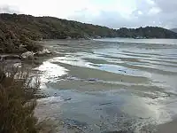
A tidal flat, or ![]() mudflat, is a tidally inundated area of bare mud or similar sediments where you will find a lot of birds, crabs, mollusks.
mudflat, is a tidally inundated area of bare mud or similar sediments where you will find a lot of birds, crabs, mollusks.
How to map
Draw the outline ![]() of the area and tag it with
of the area and tag it with natural=wetland + wetland=.
The area will be located generally outside the coastline.
surface=*may be added to specify the surface material: mud, etc.
For rocky foreshore or sand foreshore area use natural=bare_rock/rock/sand/shoal + tidal=yes instead.
Rendering
-
 On land
 -
 Over sea