Tag:natural=shoal
 |
| Description |
|---|
| An area of the water floor which nears the water surface and is exposed at low tide or when a river/lake is not full of water. |
| Rendering in OSM Carto |

|
| Group: natural |
| Used on these elements |
| Useful combination |
| See also |
| Status: de facto |
| Tools for this tag |
|
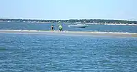
The natural= tag is used to mark an area of the water floor which nears the water surface (literally, becomes shallow) and is exposed from time to time (at low tide or when a river/lake is almost empty in summer but higher at spring for example). This tag is used for distinct raised features like sand or other unconsolidated material (shingle, gravel, pebble stones...) but not for tidal flats (i.e. muddy flats) or rocks.
How to map
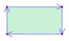
To map a shoal you can just draw a line closing on itself, marking the area ![]() of the shoal and tag it
of the shoal and tag it natural=. To map larger shoals you can use relation:multipolygon with the same tag.
If known you can add the following tags:
name=*for the name of the shoalsurface=*to specify the surface material of the shoal, for examplesurface=sandorsurface=gravelseamark:sea_area:category=shoalto mark the shoal as an object for nautical charts. If you are mapping a single node, useseamark:type=rockinstead.
Mapping caveats
This tag is not recommended for:
- features that are permanently below water - instead
natural=reefis recommended. - features that are permanently above water - use
place=islandorplace=isletandnatural=coastline(the last tag is not needed for inland pieces of water). - beaches, including the part of a beach that is below water at high tide - see
natural=beach - tidal flats, i.e. muddy areas exposed at low tide but water covered at high tide - use
natural=wetland+wetland=tidalflat.
Rendering examples
Renderings in OSM Carto in areas without water.

In area with water, yellow/orange colour becomes blue colour which means that nothing is visible if the tag surface is missing.
See also
| ||||||||||||||||||||||||||||||||