Key:road_marking
.jpg) |
| Description |
|---|
| Road markings, i.e. colored markings on the surface of traffic areas for providing information and guidance for traffic. |
| Group: highways |
| Used on these elements |
| See also |
|
| Status: approved |
| Tools for this tag |
|
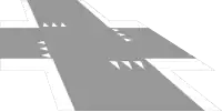
=* allows the mapping of road markings as separate geometries. These include symbols or restricted areas on the road or lane markings, e.g. at intersections.
The type and design of ![]() road markings along regular roads can in most cases be derived from other OSM tags and should therefore not be mapped with separate geometries:[note 1]
road markings along regular roads can in most cases be derived from other OSM tags and should therefore not be mapped with separate geometries:[note 1]
lane_markings=*describes whether a road has marked lanes,lanes=*indicates the number of (marked) lanes,overtaking=*allows conclusions about the design of the center line of a road in many countries, e.g., whether it is dashed or solid,change=*, similar toovertaking=*, allows conclusions about the design of lane edges,turn:lanes=*indicates the direction of travel of lanes and is usually associated with arrow markings,highway=stop,highway=give_wayorhighway=traffic_signalsindicates the presence of a stop line in many countries (the design of which can be specified with=*),crossing:markings=*indicates the type and design of markings at crossings,- parking:side describes the presence of parking areas on the road, which may be marked (parking:side:
markings=*), cycleway=*andcycleway:lane=*provide information about the presence of (marked) cycle lanes and their markings.
How to map
Use =* on separately mapped geometries, i.e. not combined with other features such as the road centerline (highway=*). [note 2] Depending on the type of road marking, they are mapped either as a ![]() line,
line, ![]() area, or
area, or ![]() node.
node.
Add =* with one of the values listed below and, if needed, additional tags, e.g. for the design of a line (stroke=*), the pattern of an area (pattern=*), the shape of an arrow (arrow=*), the representation of a symbol (symbol=*), or physical properties such as color and size. In many cases, road markings have an impact on other road properties and tags, which should always kept consistent (see the references to other tags in the last column of the table below).
If road markings are mapped in a location where the areas of roads and streets are also mapped with area:highway=*, the road markings are always mapped in addition, i.e. "on" the carriageway areas.
Typical Values
| Illustration | Value | Geometry | Description | Interdependence with other tags |
|---|---|---|---|---|
|
Describing linear markings | ||||
 |
=stop_line
|
A stop line e.g. in front of a traffic signal, traffic sign or (other) junctions. Can be mapped as a line following its real location, or alternatively as a point on the highway line (then, if necessary, exceptionally together with tags such as |
highway=stophighway=give_wayhighway=traffic_signals
| |
 |
=lane_divider
|
Lane markings to demarcate individual lanes.
|
lane_markings=*lanes=*change=*overtaking=*
| |
 |
=edge_line
|
Marking the edge/boundary of the carriageway.
|
||
 |
=crossing_edge
|
Edge/border markings of pedestrian or cycleway crossings.
|
crossing:markings=*
| |
|
Describing areal markings | ||||
 |
=restriction
|
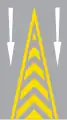
Neutral areas or restriction markings, like gore chevron or no-parking markings.
|
parking:side parking:side: restriction=*
| |
 |
=crossing
|
The (areal) marking of a crossing to map the extent of crossing markings or colored surfaces in detail. Note: In general, tags like
|
crossing:markings=*
| |
|
Describing symbolic markings | ||||
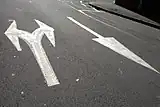 |
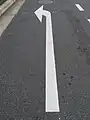
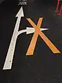
=arrow
|
 An arrow, usually to indicate turn directions, but also for indicate driving or oneway directions or overtaking hints. In contrast to other symbolic road markings, arrows are mapped as lines (instead of points) by most mappers. It is therefore recommended to map arrows as a simple line between two points corresponding to the length and direction of a single arrow with the line starting at the "foot" (base) of the arrow.
|
turn:lanes=*
| |
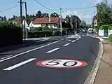 |
=traffic_sign
|
An equivalent of a traffic sign applied as a road marking.
|
traffic_sign=*maxspeed=*hazard=*
| |
.jpg) |
=text
|
Lettering on the road surface like "BUS", "SLOW" or "King St.".
|
lanes=* (like lanes:bus=*)access=* (like bus:lanes=*)hazard=*
| |
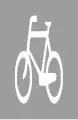
=symbol
|
A symbol or pictogram applied as a road marking.
|
e.g. cycleway=*
| ||
Additional attributes
Stroke, pattern and symbol styling
Use the tags stroke=* (for ways), pattern=* (for areas), arrow=* (for arrows) and symbol=* (for symbols) to further describe the design of road markings:
![]()
stroke=*
Use stroke=* to describe the style of linear road markings.
Some line attributes like stroke=sharks_teeth are "directed" and therefore dependent on the line direction. In this case, the stroke elements are considered to "point to the right" from the line direction (in case of shark's teeth, the tips of the teeth point to the right).
Double lane markings with different stroke styles on each side can be specified with stroke:left=* and stroke:right=* (seen in the line direction).
-

stroke=solid -

stroke=dashed -

stroke=double_solid -

stroke=double_dashed -

stroke:left=solid+stroke:right=dashed
Depending on line direction. -
stroke=sharks_teeth
Deprending on line direction. -
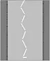
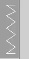
stroke=zigzag
![]()
pattern=*
Use pattern=* to describe the style of areal road markings.
-
pattern=stripes -
pattern=crosshatch -
pattern=chevron -
pattern=zigzag -
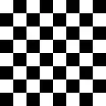
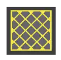
pattern=chessboard -

pattern=solid
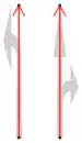
![]()
arrow=*
Use arrow=* with the common values known from turn=* to specify the form of an =arrow (like left, through, through;right, merge_to_left, reverse, ...). In rarer cases, arrow markings may also show icons known from restriction=* (like no_u_turn, no_right_turn).
Examples:
-
arrow=left -
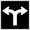
arrow=left;right -
arrow=no_right_turn -
arrow=no_u_turn
![]()
symbol=*
Use symbol=* to describe the style/form of symbolic road markings (=symbol). Use a generic term such as bicycle, pedestrian, hov (see hov=*) or airport (see also destination:symbol=*).
Examples:
Other additional attributes
There is a bunch of tags that can provide additional information describing the size or other physical properties of road markings:
width=*, especially for linear road markings to distinguish narrow from wide markings,colour=*, e.g. whether there arewhiteoryellowmarkings,direction=*on nodes to specify where the markings are facing to,length=*on nodes to specify the size of symbolic road markings (besidewidth=*).
Examples
|
|
Shark's teeth stop lines at a junction.
|
|
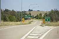
Neutral area at an exit ramp forming a theoretical gore.
|
_in_gmina_Murowana_Go%C5%9Blina.jpg)
|
Marking at a bus stop to raise attention and prevent cars from stopping.
|
.jpg)
|
A pattern on a junction that can be driven over but it is not allowed to stop within it (see also box junction).
|
|
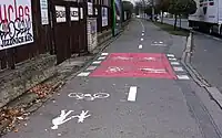
Colored road surface on a foot- and bike path, intended as a warning indicator on a crossing.
|
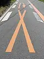
|
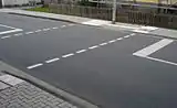
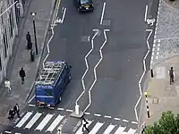
Wavy lane markings around a zebra crossing.
|
.jpg)
|
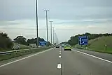
Turn lanes marked with arrows... ...and two different neutral areas |
.jpg)
|
Destination markings (arrow, text, symbol) near an intersection.
|
Possible tagging mistakes
An earlier documented but undiscussed version of =* included numerous unstructured values, most of which can be reclassified to one of the values listed above.
Footnotes
- ↑ A proposal for the use of styling attributes on
highway=*lines is still pending, but could be developed based on the=*schema (e.g.lanes=2+lane_markings=yes+lane_markings:stroke=dashed+lane_markings:colour=yellow). - ↑ An exception to this are stop lines if there is already a node with
highway=stop,highway=give_wayorhighway=traffic_signalsat their location. Although the stop line can also be mapped exactly as a separate line with=stop_line, some mappers prefer a simpler variant only mapping a node on thehighway=*line at the location of the stop line with=stop_lineand, if necessary, additional attributes such asstroke=sharks_teeth.
See also
lane_markings=*to indicate whether there are marked lanes along a roadlanes=*for the number of lanes for motorized trafficturn=*to indicate turning lanesovertaking=*for information on whether overtaking is permitted or notchange=*to indicate whether lane changes are permitted or notcrossing:markings=*to indicate the design of crossings for pedestrians and cyclists