Tag:access=private
.jpg) |
| Description |
|---|
| The feature is not to be used by the public. |
| Group: restrictions |
| Used on these elements |
| Useful combination |
| See also |
| Status: de facto |
| Tools for this tag |
|
The access= tag is indicating that the object is not to be used by the public. Access is only with permission on an individual basis.
Road or similar object does not need to be blocked with gate or similar obstruction to be eligible for this tagging.
Use private=* to clarify who exactly is allowed to use a facility (or a way) with private access.
Road usage
Common use is for objects with restricted access, such as roads where only some may drive. For example, adding access= marks a driveway (tagged as highway=service + service=driveway) as restricted – for example because it is behind a gate, or has posted signage that indicates that the property owner has chosen to disallow access by the general public.
Routing programs are able to detect this tag, and know to avoid these roads when routing.
See access=* for an overview of access tagging and also UK public rights of way for the legal situation in the United Kingdom.
Facilities
The value indicates that access is allowed only for a closed group of users, such as employees of a company, members of an association or club, or individuals. Use private=* to clarify which group is allowed to access the facility.
Examples for the access=private tag include:
amenity=parking+access=– for private parking, such as company employeesleisure=swimming_pool+access=– for a swimming pool in a private backyard.leisure=playground+access=– for a playground in a school or kindergarten.
Clarification of the term “private”
Note that access= is intended to indicate that access is restricted, not whether the object is privately owned or not. Use ownership=private or operator:type=private to record this kind of status. For example, a privately owned road with public access may be tagged like any other road with public access – without access=* tag, or with the explicit access=permissive.
Note that access restriction can be legal, gate or fence or other physical restriction is not needed. Mail delivery and trash collection services may be allowed to use access= road.
Unfortunately, some mappers have widely misused access= for any feature that they consider "private" even when access is not restricted. Driveways to individual residences are often thought of as "private" in the sense that the public is not really welcome and privacy is expected, but this cultural norm is not the same as access being explicitly restricted. In areas where access= is overused like this, the meaning of the tag is diluted and there is no way to distinguish which features have actual restricted access. Ideally this broken data would be fixed.
Examples:
-
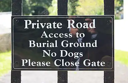 A “Private Road” sign may not mean that the public is not allowed to enter it – but about who owns and maintains it. For example, in at least some parts of the United States, a “No Trespassing” sign would also be required to prohibit entry, while “Private Road” would not prohibit entry.
 -
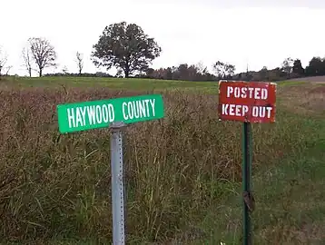 “Posted” and “Keep Out” are also commonly used on signs in the U.S. to indicate restricted access. Note that in many cases there are no gates, fences or other physical obstructions.
access=still applies where access is restricted in such way.
Relation to access=no
Sometimes access=no is described as a stronger version of access=. For example, a stretch of roadway may be closed with a “Road Closed” sign and barricades due to serious damage to a road or a long-term construction project. There may be a physical reason why no one would realistically be able to traverse the road. If applicable, also map any barriers that prevent anyone from entering or traversing the road.
Note: Long term construction projects are often mapped by retagging such roads to highway=construction + construction=*.
Rendering
 at osm-carto