Tag:area:highway=steps
 |
| Description |
|---|
| An area representation of steps. |
| Group: highways |
| Used on these elements |
| Useful combination |
|
| Status: in use |
| Tools for this tag |
|
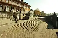
An area representation of a highway=steps which is separately mapped with a linear way.
Background
Some steps take up a significant areas - or mappers are interested in super-accurate mapping - so this tag was developed to precisely map this, in addition to highway=steps way tagged through their middle.
How to map
Correct tagging
- If it's a simple steps area, just draw outline around it, and add tag
area:highway=. - If it's a more complicated one, draw an outline around it, draw all inner parts, then select all elements and make a multipolygon relation from it. Add tag
area:highway=to multipolygon. - Remember about joining area's edges to surrounding buildings, walls, etc.
Linear routable way
- Always create also a linear
highway=stepsway along the centerline of thearea:highway=as described inarea:highway=*area:highway=without matchinghighway=stepsline is always wrong, it should be mapped solely in addition to existinghighway=steps