Tag:area:highway=pedestrian
 |
| Description |
|---|
| An area representation of pedestrian zones. |
| Group: highways |
| Used on these elements |
| Useful combination |
|
| Status: in use |
| Tools for this tag |
|
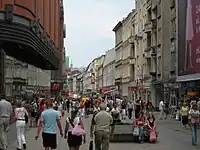
An area representation of highway=pedestrian. area:highway= describes the shape, i.e. the two-dimensional outline, of the area of a pedestrian street, or parts of it.
It is meant for areas that have a clear direction of travel, and is used as a form of Micromapping in addition to the routable, linear way tagged as highway=pedestrian. Specifically, it is not the same as highway=pedestrian + area=yes, which represents a non-linear area, such as a square or plaza, where multi-directional travel is possible.
How to map
Correct tagging
- If it's a simple pedestrian area, just draw an
 outline around it, and add tag
 area:highway=. Then add a linearhighway=pedestrianway through its middle or else most navigation software cannot route correctly through it! - If it's a more complicated one, draw an outline around it, tag it with
area:highway=, draw all inner parts, then select all elements and make a multipolygon relation from it. Also add a linear
 highway=pedestrianway through the middle of all usual paths in the pedestrian area! - Remember to join the areas' edges to surrounding buildings, walls, etc.
[!] For usual footway areas (see differences between highway=pedestrian and highway=footway) use area:highway=footway, and for cycleway areas use area:highway=cycleway
Optional tags:
surface=*(What is the pedestrian area paved with, if anything? e.g. concrete, asphalt, etc.)
Tagging mistakes to avoid
- Don't leave an
area:highway=area alone. Always add a linearhighway=pedestrianway going through its middle for the area to be routable in navigation software! - Don't use an
area:highway=tag to map the area of footways which are too narrow for vehicles to enter. Usearea:highway=footwayfor them. - Don't draw an
area:highway=area for pedestrian crossings. Correct tagging of them is explained in a second table below. - Don't draw an
area:highway=area for cycleway areas. Usearea:highway=cyclewayinstead. - Don't use an
area:highway=tag for non-separated "foot & bicycle" path areas. Usearea:highway=pathtag instead. - Don't use an
area:highway=for traffic calming islands without any crosswalk connection. Use onlytraffic_calming=islandtag instead.
Example tagging
| Case | Area tags | Mapping examples |
|---|---|---|
area:highway=
|
.jpg)
| |
area:highway= Correct tagging of pedestrian multipolygon depends on character of place, you can:
|
.jpg)
|
Example tagging of connected objects
| Case | Way tags | Area tags | Diagrams | Mapping examples | ||
|---|---|---|---|---|---|---|
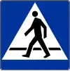
Pedestrian crossing |
highway=footway |
Draw an area around streets intersection, treating stop lines and crossings as its edges and tag it with:
If it's a single crossing being far away from streets intersection, draw it just as a linear way crossing street area without |

|
.jpg)
| ||
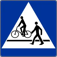
Non-segregated "foot & bicycle" crossing |
highway=path + |
Draw an area around streets intersection, treating stop lines and crossings as its edges and tag it with:
If it's a single crossing being far away from streets intersection, draw it just as a linear way crossing street area without |
|
.jpg)
| ||
|
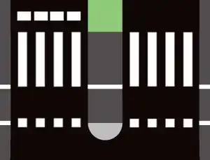
Segregated "foot & bicycle" crossing |
Method 1 (one linear way):
|
Draw an area around streets intersection, treating stop lines and crossings as its edges and tag it with:
If it's a single crossing being far away from streets intersection, draw it just as a linear way crossing street area without
|

|
.jpg)
| ||
Method 2 (two linear ways):
|
|
.jpg)
| ||||
|
Segregated "foot & bicycle" crossing with traffic calming island |
Method 1 (one linear way): |
Draw an area around streets intersection, treating stop lines and crossings as its edges and tag it with:
If it's a single crossing being far away from streets intersection, draw it just as a linear way crossing street area without
|
|
.jpg)
| ||
highway=path + |
highway=path + |
highway=path + | ||||
Method 2 (two linear ways):
|
|
.jpg)
| ||||
highway=footway |
highway=footway
|
highway=footway | ||||
| ||||||
highway=cycleway |
highway=cycleway
|
highway=cycleway | ||||
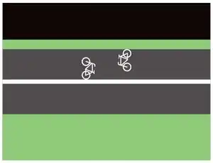
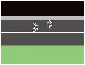
Segregated "foot & bicycle" path |
Method 1 (one linear way):
(path way should be joined through a mutal part of the footway/ cycleway areas, see example screenshot) |
(both areas should be joined to each other if there is no physical barrier between them, see example screenshot) |
|
.jpg)
| ||
Method 2 (two linear ways):
|
|
.jpg)
| ||||
| Traffic calming paving on a street edge (This element should be treaten as kind of a traffic calming area, not footway) |
traffic_calming=island
|
|
.jpg)
| |||