Tag:man_made=dyke
 |
| Description |
|---|
| An embankment built to restrict the flow of water or other liquids |
| Group: man made |
| Used on these elements |
| Useful combination |
|
| See also |
| Status: de facto |
| Tools for this tag |
|
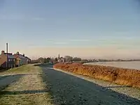
An embankment built to restrict the flow of water or other liquids. Also known as a levee.
How to map
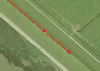
Draw a way ![]() along the top of the dike. This is often seen on aerial photographs at the transition between sun and shade. Tag this with
along the top of the dike. This is often seen on aerial photographs at the transition between sun and shade. Tag this with man_made=. Optionally, if the dike has a name, you can add this with name=*.
If there is a road/path or railway on top of the dyke, draw the highway or railway and use embankment=dyke instead.
For closable openings in the dyke, for example for a road or railway, see the tag barrier=coupure. The opening can be closed with for example a door, metal bars or sand(bags)
See also
man_made=embankment- Raised bank which often carries a road, rail or waterwayembankment=yes- A generic value for embankmentsembankment=dyke- To be used if there is a highway or road on top of the dyke. Use this instead ofman_made=waterway=dam- A wall built across a river cross-flow directionman_made=breakwater- breakwater is a structure surrounded by water- Proposed features/Dyke (abandoned)