Key:embankment
 |
| Description |
|---|
| A dyke or raised bank to carry a road, railway, or canal across a low-lying or wet area. |
| Group: properties |
| Used on these elements |
| See also |
| Status: de facto |
| Tools for this tag |
|
=* is a key that can be added as a property to an element such as a highway=* or railway=* to indicate whether it is placed on a raised bank, with a downward slope on one or two sides. If this ![]() embankment is above a low-lying area that is permanently or tidally flooded, then the raised bank can also more specifically be called a
embankment is above a low-lying area that is permanently or tidally flooded, then the raised bank can also more specifically be called a ![]() levee or
levee or ![]() dyke.
dyke.
A track, road or railway on the upper point of an embankment across "a low, or wet place, or piece of water" is also called a ![]() causeway.
causeway.
For embankments mapped as a separate element in Openstreetmap, see man_made=embankment or man_made=dyke
How to map
Draw a way and add the appropriate highway=*, railway=* or waterway=* tag as a top-level tag for the element. Add the embankment tag with either one of the documented values from the table below or another value as can be found on taginfo
When mapping embankments as separate elements, you can also draw two parallel ways and add man_made=embankment to both. See below.
Unlike bridges, a layer tag is rarely needed for embankments and should not be used without a good reason.
Actual usage
Main usage: whether or not a way is raised on an embankment
The two values for =* that are used most often describe whether or not a way is raised onto an embankment: =yes and =no together make up more than 96% of all usage as per Taginfo 2023-01
| Tag | Value | Description |
|---|---|---|
|
yes
|
The way is raised onto an embankment |
|
no | The way is not raised onto an embankment |
Other usage: the side(s) the downward slopes are located
Some 2% of usage of =* describes on which side of the OSM-way the downward slope(s) are located, with undocumented values such as =left ; =right ;=both or =two_sided
Other usage: the subtype of embankment
Some 2% of usage of =* describes the subtype of the embankment, such as :
|
dyke
|
An embankment for flood protection (called a dyke or levee) which also carries a road or railway. Also see man_made=dyke when there is no highway or railway constructed on top
|
or undocumented values such as =levee or =noise_barrier
Since using =* for describing the subtype of the embankment prevents using =* for the location of the downward slope -and vice versa- such specific details are best described in a specific sub-key such as embankment:type=* and embankment:side=*
Rendering
Single line embankments
Embankments that share a way with a highway, railway or waterway should be rendered with "spikes" on both sides.
This is supported in Osmarender (which is no longer maintained) and alt-Carto style from Tracestrack.
Embankments as separate elements
Embankments as separate elements in OSM should be rendered with the left-hand side of the way being the high side and the right-hand side being the low side. (Supported by OSM Carto, but only for non-closed ways that are tagged with man_made=embankment, not for those tagged with =yes.)
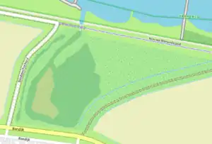
- To represent a raised finger of land (as in the illustration): draw two ways bordering the raised land, each tagged
man_made=embankmentand going in opposite directions. - To present a banked enclosure (such as an iron-age hill fort): draw two ways with the outer way travelling anticlockwise and the inner way clockwise. Additional ways can be used to present ditches, scarps, aprons and terraces in large sites. Note that if a closed way is drawn without two breaks (creating two separate but connected ways) then it will be interpreted as an area and not displayed in the Standard layer.
Gallery
-
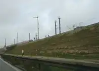
.png) Road on an embankment (between a bridge and a cutting)
Road on an embankment (between a bridge and a cutting) -
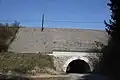 Tunnel and railway embankment near Přibyslavice.
 -
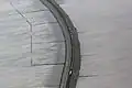
 Embankment at Argyll Road Looking out from the tunnel under Glasgow Road.
 -
 Road embankment work - Hatton Bends.
 -
Railroad embankment.
-
 Vale of Rheidol Railway Embankment.
 -
 Railroad causeway on top of an embankment.
 -
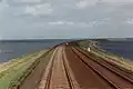 Railroad causeway on top of an embankment.
See also
cutting=*- Signifies that a linear feature (e.g. a road) cuts into the surrounding landbridge=*- A bridge is an artificial construction that spans features such as roads, railways, paths, waterways or valleys and carries a road, railway or other featurenatural=cliff- A vertical or almost vertical natural drop in terrain, usually with a bare rock surface. The bottom of the cliff is on the right side of the waynatural=ridge- A mountain landform with a continuous elevated crest or linear hillman_made=embankment- An artificial steep slopeman_made=dyke- An embankment built to restrict the flow of water or other liquidsbridge=boardwalk- Plank walkway- Talk:Relations/Proposed/Bridges and Tunnels#The same for embankments
- Landform examples
- Embankment (transportation) on Wikipedia
- Causeway on Wikipedia