Tag:water=stream_pool
 |
| Description |
|---|
| A stream pool: a small but relatively deep collection of fresh water, occurring along a narrow stream. |
| Group: water |
| Used on these elements |
| Requires |
| Useful combination |
|
| See also |
| Status: in use |
| Tools for this tag |
|
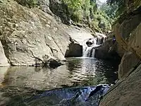
The tag water= is used to map the water area of a stream pool: a small but relatively deep collection of fresh water, occurring along a narrow stream. Water velocity in the pool is typically much lower than in the stream. Frequently found below a waterfall, where it is also called a "plunge pool". May be used as a "swimming hole".
This tag is used for pools along narrow streams which are otherwise only mapped as a linear way with waterway=stream. For wider rivers (mapped with waterway=river), the areas of the river, including "pools", are typically mapped with waterway=riverbank or water=river instead.
How to map
Draw the outline ![]() of the stream pool and add
of the stream pool and add natural=water + water=.
If the pool has a commonly-used local name, it may be tagged with name=*.
Add intermittent=yes if the pool is only filled with water some of time.
There should also be a linear way with waterway=stream continuing through the pool, with the name of the stream if there is one.
See also
water=lake- a natural or semi-natural body of relatively still fresh or salt water, localized in a basin that is surrounded by land.water=pond- a pond: a body of standing water, man-made in most cases, that is usually smaller than a lakewater=reservoir- A reservoir or an artificial lake used to store water. Usually formed by a dam over a natural water coursewaterway=riverbankorwater=river- The water area of a river, which should containwaterway=riverinside.- Prior discussion on tagging mailing list: https://lists.openstreetmap.org/pipermail/tagging/2020-December/057382.html