This page covers miscellaneous mapping guidelines for various features in Thailand that do not fall under primary infrastructure categories. These guidelines aim to provide clear, consistent standards to ensure accurate representation of diverse elements within the OpenStreetMap database, reflecting both global tagging norms and local considerations.
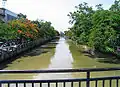
If the name of the waterway contains the word "Khlong" (Thai: คลอง) or if it looks like a typical canal or khlong we should tag it as "canal". Add boat=* where appropriate.
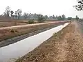
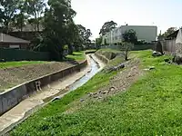
If it is made out of concrete (คอนกรีต) or build from other hard materials, it is maybe a "drain". A drain does not nessessarily contain water all the time. In dry seasons it could be dry and only be filled while it is raining! If the width exceeds and the drain does contain water most of the time consider using waterway=canal instead.
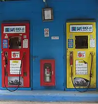
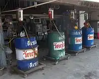
Fuel Dispensing Facilities
In Thailand, there are three primary types of fuel-dispensing facilities: fuel stations, fuel vending machines, and drummed fuel shops. Distinguishing between these categories is essential for accurate mapping.[1]
Conventional fuel stations in Thailand are equipped with sizable underground fuel storage tanks that can accommodate most types of motor vehicles. These establishments offer a range of services beyond simple fuel dispensing. Trained attendants are usually available to assist customers with refueling, and many stations also provide supplementary conveniences such as convenience stores, restroom facilities, car wash services, and automotive repair options.
Fuel Vending Machines in Thailand are small automated fuel dispensing points, prevalent in remote or less-traveled areas. These machines provide fuel without additional services and are typically situated on roadways or in front of shops. Customers can self-serve by inserting cash or coin and pumping fuel. It's important to note that these vending machines have limited fuel capacity and can sometimes be out of order. These facilities primarily serve motorcycles.
Drummed fuel shops in Thailand are small establishments that primarily sell and dispense fuel from barrels. These shops are often located in remote or less-traveled areas. They primarily provide fuel without offering additional services and are typically manned during the day as long as fuel is available. Drummed fuel shops typically serve small quantities of fuel, around 7 liters at a time, making them a popular choice among motorcycle users.
Outdoor Tagging
Hiking
Check out this Mapping Guide for Hikers in Thailand, organized into basic, intermediate, and advanced contributions sections: WikiProject Thailand/Hiking Guide
There are many cyclists in Chiang Mai, but almost no officially signposted cycleways or -routes exist. There have recently been some efforts from the Chiang Mai cycling community to collect information about common routes used by cyclists. For this, we tried to figure out how to use OSM conventions to mark roads as cycling routes. This could be a proposal for a convention to establish cycling routes in Chiang Mai and maybe other regions in Thailand.
Objective tags
The following tags should always be considered, because they can be easily verified on the ground and are also used by most cycling routing engines:
key:highway: the lower the road class, the lesser traffic and lower speeds can be expected, e.g. highway=unclassified or residential would be more suitable for cycling than highway=primary or secondary etc.
key:lanes: lanes=1 normally best suited for cycling, because less traffic can be assumed than on roads with >1 lane
key:surface: if the road is paved or not makes a big difference for cycling and should therefore be included in cycling related editing
key:bicycle: only refers to the legal (e.g. signposted) access for bicycles on roads. It is therefore not a measure for the suitability for cycling
Subjective tags (no ground truthing possible)
Subjective tags can help to give more in-depth information about the cycling suitability of a road, which cannot be determined by the objective tags alone. They should only be used if the user has a good local knowledge.
class:bicycle=1: Prefer (decent car traffic, but still better than other roads, or road is not in a good condition like dirt road with holes)
class:bicycle=2: Very Nice way to cycle
class:bicycle=3: This way is so nice, it pays out to make a detour also if this means taking many unsuitable ways to get here. Outstanding for its intended usage class.
class:bicycle=-2: Only use to reach your destination, not well suited (e.g. big junctions, but have to be passed to connect to another calmer road).
key:scenic: If the scenery of a specific part of the road is remarkably beautiful, this key can help to rank the amenity of a cycling-suitable road.
In order to propose possible cycling routes (local and regional) for a cycle-route network, the key:lcn or key:rcn tags can be helpful. Furthermore, the cycling roads will also be rendered on the OSM-cyclemap[1], which is also being used on the main openstreetmap.org "Cycle Map" layer.
key:lcn=proposed (for local routes, e.g. inside the city bounds)
key:rcn=proposed (for regional routes, e.g. to other districts/provinces)
The key-value would be 'proposed' for now, since these routes are not officially designated. Routes should only be proposed if they have been tested on the ground and/or been agreed on by the local cycling community.
If there are any designated routes (not existing in Chiang Mai yet), of course they should be tagged as lcn=yes / rcn=yes.
Hike Mapping Guide
Thailand has a vast network of trails, from well-known national park paths to hidden jungle routes. Contributing to OpenStreetMap (OSM) helps improve navigation and benefits the hiking community. Mapping your hikes makes trails safer and more accessible. Every contribution, big or small, helps! Here’s how you can contribute:
Basic Contributions
Track Your Hike
Use GPS-enabled apps like OsmAnd, AllTrails, Strava, or Gaia GPS to record your hike.
Ensure high accuracy by letting the device get a good GPS signal before starting.
If using a dedicated GPS device, save your tracks in GPX format.
Take Notes & Photos
Mark key points such as signs, gates, trailheads, junctions, viewpoints, shelters, water sources, and obstacles.
Take geotagged photos for reference.
Share Your Knowledge
If you don’t want to edit OSM directly, share your tracks and observations publicly on platforms like GaiaGPS, AllTrails, Strava or Komoot.
Engage with local hiking groups (Chiang Mai) to encourage more contributions.
Respect Nature & Local Communities
Follow Leave No Trace principles.
Be mindful of private property and local regulations.
Use the sac_scale tag to classify trail difficulty, avoiding the use of signed/legal access tags (e.g., foot=yes/no).
Congratulations on making your first edits! Your changes will appear in OSM-powered applications within a few days to weeks (or months), depending on how often they update their maps!
Add missing gates, obstacles, and other relevant details at the respective nodes.
Verify & Improve Existing Data
Cross-check existing OSM data with your recorded and public tracks.
Review available Photo Imagery in iD, such as from Mapillary.
Realign trails using the iD Strava Heatmap and OSM GPS Traces overlays.
Discuss Best Practices
Engage with local OSM communities (Forum, Facebook) to discuss mapping standards.
Common Tagging Mistakes
Avoid using access tags on trails (e.g., access=yes/no, foot=yes/no) that are not explicitly marked with signage or legal restrictions. Instead, use the sac_scale tag to classify trail difficulty.
Do not use the name tag for trails without official/signed names. Instead, use the description tag.
Do not use a single GPX trace to realign a trail. Check for other public traces via the OpenStreetMap GPS Traces layer and Strava Heatmap extension, and average them if available.
Do not use highway=track for double tracks that serve a different function than agricultural and forestry. For instance use highway=unclassified for tracks linking settlements, and highway=residential for tracks giving access to residences.
Happy hiking and mapping!
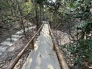
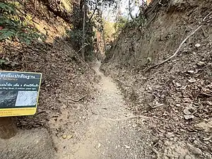
Examples
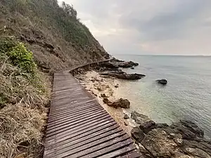
National Park Managed Trails
For trails managed by the Department of National Parks, open to the public, and requiring an entrance ticket.
Note: Some trails within national parks require a special permit that must be obtained in advance. These trails are not accessible to the general public, even with a standard park entry ticket. In such cases, use access=permit to indicate the restriction.
operator=Department of National Parks, Wildlife and Plant Conservation
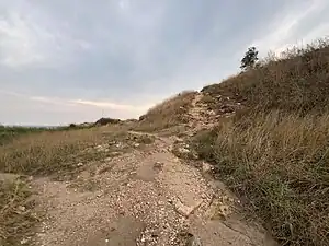
Public Trails
Public trails in farmlands and forests are commonly used by locals on foot to gather forest products and by motorcyclists to access farms and settlements. These trails generally don't have access restrictions, and vehicles, including motorcycles, are typically allowed. However, some trails may be maintained by farmers or villagers, and outside visitors may not be welcomed. In such cases, it's best to avoid mapping these trails and instead focus on the surrounding paths that provide public access to the forests.
_19.jpg)