Zh-hans:Tag:waterway=weir
 |
| 说明 |
|---|
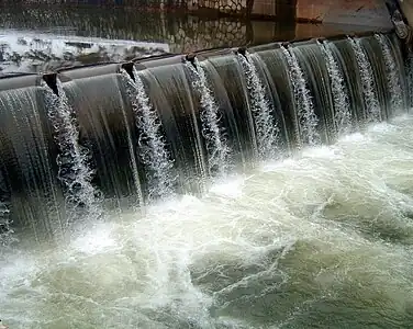
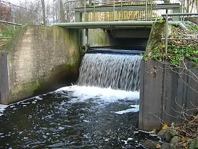
| 跨河修建的拦水构筑物,用于控制水位和流速。水仍可从顶部流过。 |
| 在OSM Carto中渲染 |
| 在OSM Carto中渲染 |

|
| 组: 水域 |
| 用于这些元素 |
| 常用组合 |
|
| 状态:已批准 |
| 此标签的工具 |
跨河修建的拦水构筑物,有时用于工业用途调水。水仍可从顶部流过。
如何绘制
要绘制小堰,在河流上添加一个节点并标记为waterway=。如果堰有名称,则用name=*标注,
如果堰的长度足以绘制为一条路径,则沿着堰的长度创建一条路径,并将其标注为waterway=。如知名称,添加一个name=*标签。waterway=weir应该与穿过它的河流共享同一节点。如natural=cliff一样,线条方向也很重要:左侧是高侧,右侧是低侧。
有时会有鱼道在堰附近。
堰上路
This subject was not part of the proposal but the most straightforward solution is that the highway=* and waterway= share a way. A section of this way may be marked with ford=yes if there is a ford.
Validators and QA tools may complain about this combination because they may have an overly generic rule saying that highways and waterways can not share a single way - this is one of the valid exceptions and tools should be fixed to accept it.
渲染
| 类型 | 图片 | 标签 | OSM Carto |
|---|---|---|---|
|
waterway=
|
| |
|
|
waterway=
|
|
参见
waterway=dam- 坝,水不可从顶部流过的拦水构筑物waterway=fish_pass- 以
natural=water+water=fish_pass- 鱼道,一般在水坝与船闸附近修建,供鱼类洄游的通道。landuse=reservoir或natural=water+water=reservoir用于拦蓄形成的水库。waterway=lock_gate- 船闸waterway=canoe_pass
网页链接
- Weir(维基百科条目)