Zh-hant:Tag:highway=trunk
 |
| 說明 |
|---|
| 非高速公路的重要道路。 |
| 在OSM Carto中渲染 |

|
| 組: 道路 |
| 用於這些元素 |
| 暗含 |
| 常用組合 |
| 参照 |
| 狀態:習慣使用 |
| 此標籤的工具 |
使用highway=標記高品質或重要性高的道路,不須達到motorway的要求。
在不同的國家,無論品質或重要性都是定義的標準。關於不同國家道路分類的指引,請參見#International equivalence與Highway:International equivalence。
注解:在臺灣,快速道路為省道快速公路(紅色盾形標誌)或市區快速道路,如新北市環河快速道路、省道台61線西濱快速道路等。
如何繪製
繪製一個簡單的快速道路,您只需為它畫一條線,選擇屬於該道路的所有路徑,並使用highway=primary標記。當道路無法雙向行駛時,使用oneway=yes標記,並確保路徑方向與行駛方向一致,否則請翻轉路徑方向或使用oneway=-1(建議當路徑方向無法翻轉時使用)。
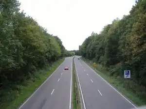
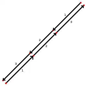
在雙向行車道的案例中,您應該為每個行車道繪製路徑,並為不同方向分別標記。將節點定位在對齊的位置(如圖),將為渲染地圖時提供更好的結果,並直接指示兩條路徑隸屬相同的道路。
為道路加入更多資訊,請進一步添加下列標籤:
name=名稱- 道路名稱。例如:「西部濱海快速道路」、「 West Coast Expressway」maxspeed=數字- 道路法定最高限速(公里每小時)。例如:「90」minspeed=數字- 表示行駛道路必須達到的最低限速ref=編制名稱- 道路的編制號碼,請參見該國道路的識別系統。例如「61」loc_name=名稱- 非官方或地方道路名稱maxweight=數字- 最大載重限制(噸)。例如「5.5」surface=*- 道路路面材質說明。例如「asphalt(柏油)」width=數字或est_width=數字- 道路寬度(公尺)。例如「45」lanes=數字- 道路可使用的車道數,常為「4」或「6」motorroad=*如果該道路有限制機動車輛的交通規範toll:N3=yes- 最大允許載重大於12公噸的卡車需收取通行費destination=*表示道路通往的目的地。請考慮路徑的方向,並使用寫在屬於trunk_link道路指示標誌上的城市名稱:例如「彰化」(關於trunk_link,請參見highway=motorway_link)
特殊情況
下列位置非屬一般快速道路:
highway=trunk_link- 通往或離開快速道路的聯絡道路(滑行道/坡道)。bridge=yes+layer=1- 如果快速道路橫越街道或水路。tunnel=yes+layer=-1- 如果快速道路穿越街道或水路下方。
各國案例
下列為各國如何分配標籤的比較表,用戶應查閱特定國家的指南以了解更多詳細訊息及其他標籤。
關於各國特定計畫與如何標記各國特定標籤的指南列表,請參見Category:Projects。
| 國家 | 快速道路說明 | 更多詳情 |
|---|---|---|
| National highways; state strategic road network. Connecting major population centres. For example Bruce Highway, Pacific Highway. |
Australian Roads Tagging | |
| Autostraße |
WikiProject Austria/Schnellstraßen | |
| Autoweg |
||
| Rodovias duplicadas (divided highways), vias expressas urbanas (urban expressways) | ||
| Скоростен път с поне две ленти във всяка посока. Ограничението на скоростта не трябва да е по-малко от стандартното (50 км/ч за населени места, 90 км/ч извън тях). | ||
| 国道(not superceded by expressways)/城市快速道路 | ||
| Expressways (Brza cesta) and motorroads (cesta za promet motornih vozila) WikiProject Croatia/Ceste | ||
| Silnice pro motorová vozidla: |
||
| Motortrafikvej |
Da:Map Features | |
| Valtatiet/National Highways | Fi:Map Features | |
| Rocade, voie rapide ou voie express. Voie ayant les caractéristiques d'une autoroute. En général, une 2x2 voies avec séparation centrale. Par défaut : lanes="2", maxspeed="110" (sauf périph. Paris: 80) + ref="Nxx" ou "Dxx" + oneway="yes" + lanes="x" (si voies <> 2) |
FR:Map Features | |
| For Motorway Like Roads (Autobahnähnliche Straße collq. Schnellstraße) without crossings. The carriageways are separated physically or by road markings. Motorway-like junctions with exit signs |
DE:Tag:highway=trunk | |
| 1st-tier National Roads | WikiProject Greece § Road Network | |
| Roads with route number, but not expressways or tunnels | Zh-hant:Hong Kong tagging#街道分類 Classifications of streets | |
| Autóút | ||
| National Roads. Different by island. | ||
| The Expressways according to the definition of Iranian National Standardization Organization. | ||
| National Primary Routes, regardless of build quality. Currently numbered N1-N33. Signed in white lettering on a green background. | ||
| National Primary Routes, regardless of build quality. They are numbered with one or two digits. Red numbers on a white background surrounded by green border. |
He:Map Features | |
"Strade a scorrimento veloci" (~roads for high travel speeds) with on ramps and off ramps and without level crossings or roundabouts, a road class generally between primary roads and motorways. For mapping access restrictions similar to motorways, use the tag motorroad=yes. Usually the major roads between cities are of this type.
|
||
| 国道/National Highways | ||
| Rocade, expressway.2x2 Divided highway, every intersections with roundabout.speedlimit 80 or 100 km/h | ||
| Autoweg |
NL:Map Features | |
| Strategic State Highways State Highways linking major urban areas (population 30,000+), major ports, major airports, international tourist destinations, and/or remote regions. Generally two lanes undivided with regular passing lanes. All State Highways not meeting the criteria should be tagged highway=primary.
|
||
| Nation infrastructure road (Riksvei) that are not "Motorvei" , green signs, include E-roads class A and B |
No:Map Features#Road classes | |
| Primary national roads connecting major cities and provinces. Examples are the Pan-Philippine Highway/AH26 (not including toll expressway segments, like segments on NLEX and SLEX) that are tagged highway=motorway) , Daang Maharlika, MacArthur Highway, EDSA (includes portions not marked as part of Pan-Philippine Highway/AH26), Aguinaldo Highway, Governor's Drive, Jose P. Laurel Highway (mostly designated as Manila - Batangas Road, but short segment at Santo Tomas is designated as Santo Tomas Bypass Road) , Andaya Highway, Strong Republic Nautical Highway, etc.
|
Philippines/Mapping conventions#Roads | |
| WikiProject Poland/Klasyfikacja dróg | ||
| Via Rápida | ||
highway= is used for any national road part of a European corridor or express ways (do not exist in Romania); along with the national road shield (white on red background) ref=* tag has the format DNn, DNnn or DNnnx (n=0-9, x=A-Z), while the tag int_ref=* has the format Enn or Ennn.
E.g.: DN6/E60, DN2/E85 . |
Ro:Map Features#Drumuri | |
| Cesta pre motorové vozidlá: |
||
| Divided highway without ramps. Higher speeds. Few stop lights or stop signs. |
||
| Trunk roads (stamväg) as defined by the state, including all European routes and certain other national roads (riksväg). Exceptionally also shorter stretches of other roads having similar importance locally. | ||
| Autostrasse / autoroute de 2eme classe (semi-autoroute) | ||
| Refers to a (paved) 'Trunk Road', as classified by Tanroads. Main roads that connect major cities in the country: e.g. T1 from Dar es Salaam - Zambia border. | ||
| primary A road (green signs) | ||
| Surface expressway: A relatively high-speed divided road (at least 40 MPH with a barrier or median separating each direction of traffic), with a limited amount of intersections and driveways; or a major intercity highway. This includes many U.S. Highways (that do not parallel an Interstate) and some state highways. | Wikipedia reference | |
| Main roads used for the vast majority of trunks (T-XX, Troncal XX) that run across the country, and that generally connect one city with another. In some places some of the local roads (L-XX, Local XX) will also be included. | ||
| Trunk (Xa lộ) in Vietnam usually have more than 3 lane with lane classification signs. |
範例
| 圖像/說明 | 標籤 | Mapnik |
|---|---|---|
|
|
(標記單向行車道)
|
|
| ||||||||||||||||||||||||||||||||||||||||||||||||||