Tag:aerialway=zip_line
 |
| Description |
|---|
| Zip line, gravity propelled aerial ropeslide like a flying fox or similar |
| Rendering in OSM Carto |
|
| Group: aerialways |
| Used on these elements |
| Implies |
| Useful combination |
| Status: de facto |
| Tools for this tag |
|
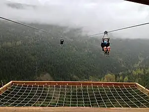
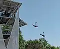
A ![]() zip line is used to transport people or material down a inclined fixed rope or wire, typically without propulsion sliding down by gravity. The person should be secured with a climbing harness. There may be auxiliary wires for security or operation. This tag might be also used to tag
zip line is used to transport people or material down a inclined fixed rope or wire, typically without propulsion sliding down by gravity. The person should be secured with a climbing harness. There may be auxiliary wires for security or operation. This tag might be also used to tag ![]() Tyrolean traverses.
Tyrolean traverses.
- For zip lines on playgrounds see also
playground=zipwire.
How to map
Draw a way in the direction of travel and tag with aerialway=.
Zip lines imply oneway=yes by default but can be explicitly marked with oneway=no when the zip line is allowed in both directions.
Tags used in combination
name=*access=*fee=*opening_hours=*maxweight=*maxspeed=*incline=*duration=*oraerialway:duration=*
In playgrounds
leisure=playgroundmin_age=*,max_age=*attraction:minheight=*,attraction:maxheight=*,attraction:minheight:escorted=*- for example, attraction:minheight=120 or attraction:maxheight=195
In forestry and privately
access=private/forestry/...
For goods
foot=no– passengers explicitly forbiddenusage=freight– used for freight; passengers or personnel may be allowed in some cases (+ foot=yes )usage=industrial– freight transport in industrial areas or mines
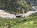
Examples
Forestry zip line used for downhill transport of logs:
Gallery
_(51360305960).jpg)
See also
bridge:structure=simple-suspension– primitive wire/rope bridgessport=climbing_adventure– area used for various types of high-rope coursesplayground=zipwire- Ropeway on a playgroundhighway=via_ferratasac_scale=*
| ||||||||||||||||||||||||||||||||||||||||||||||||||