Tag:aeroway=runway
.jpg) |
| Description |
|---|
| A strip of land on which aircraft can take off and land. |
| Rendering in OSM Carto |
|
| Group: aeroways |
| Used on these elements |
| Useful combination |
| See also |
| Status: de facto |
| Tools for this tag |
|
A runway is a defined rectangular area on a land aerodrome (aeroway=aerodrome) prepared for the landing and take-off of aeroplanes.
How to map
Draw a way along the centre line of the runway, from one edge to the other, and add the aeroway= to it. Information on the width of a runway should be added using the width=* tag (see below).
aeroway= is mapped from runway edge to runway edge: this includes parts of the runway marked as displaced thresholds, but excludes blastpads and stopways.
Additionally, the whole area ![]() of the runway may be mapped as well, tagged with
of the runway may be mapped as well, tagged with area:aeroway=runway. (Previous common practice was to tag such with aeroway= + area=yes; this can be safely retagged. As of February 2022, taginfo reports that aeroway= is combined with area=yes 2,754 times, while area:aeroway=runway has 2,038 uses, a significant increase from January 2020.)
Tags to use in combination
ref=*– the runway designator (for example "02/20" or "09L/27R"). List the smallest designator first (i.e. "04/22", not "22/04"). The two designators of a runway will always differ by 18 (180 degrees) and can have one letter appended (L, C, R or T). Only use other values in special cases. Be aware that the US do not adhere to the ICAO standard, and do not publish leading zeroes; i.e., their fields will have a 2/20 rather than a 02/20. There is a tendency for heliports to also have (shortish) runways, so that helicopters can operate to procedures similar to fixed wing. Such runways can then have an H in the ref; see https://www.openstreetmap.org/way/585516454 for one example.length=*– length in metres. The length is measured including thedisplaced_threshold.width=*– refers to the width of the actual runway surface. These are usually standardized, typical values are 60 m, 45 m, 30 m, 23 m or 18 m. Only use other values in special cases.ele=*– should be used for the average elevation of the runwaysurface=*– to be used to identify the physical makeup of the surface of the runway. Example: "paved" or "grass".centerline=*– yes/no indicates whether there is a centerline on the runway or not.name=*– If the runway has a distinct name. Should not be a copy of ref. Examples: "Polderbaan" and "Aalsmeerbaan" at Amsterdam airport.
Additional information
Additional information can be specified using these keys:
| Tag | Description |
|---|---|
source:date=* |
If imported/updated from the FAA 56-day NASR database, this tag will contain the date the database became valid. |
incline=[±]d.d% |
The incline (as a ratio) of the runway. The direction of the way is from approach to departure. It is the gradient between the departure threshold and the approach threshold; i.e., the elevation of the former minus that of the latter, divided by their distance. |
incline:spec=[±]d.d%reverse_incline:spec=[±]d.d%
|
The incline (as a ratio) of the runway, as specified in the FAA airport diagram. According to the legend diagram, this is specified if the absolute value is ≥ 0.3%, and is measured to the midpoint of the runway (instead of the far threshold) if the runway is ≥ 8000 ft. The first (undecorated) tag is the incline in the direction of the way, and the reverse_incline tag in the opposing. |
FAA:LFSN=* |
The FAA Landing Facility Site Number for the airport with which the associated runways should be tagged. There is generally no reason to edit this value; it is used to refer back to the associated aeroway=aerodrome node or way and the FAA database for synchronization of imports. Example: "01818.*A" is the LFSN for LAX.
|
source=* |
Sources of information present in tags, semi-colon-delimited. "FAA" indicates at least some information from one or more FAA databases or imports. Often combined with an imagery tag to indicate the imagery with which the boundary was drawn. |
source_ref=* |
Key to source documents. Example: when source=FAA, you may see source_ref=nnnnnAD, which indicates the document number of the FAA Airport Diagram, which are at http://aeronav.faa.gov/d-tpp/vvvv/''nnnnn''AD.PDF where vvvv is the version number (incremented every 56 days). |
lit=*lit:centre=* |
To indicate whether the runway is lit. If lit=yes is used, edge-lights are assumed to be present. Add lit:centre=yes to indicate the presence of centreline lights.
|
Features that occur in this context
![]()
![]()
![]()
Lifecycle
- Main article: Lifecycle prefix
| Stage | Tagging | Notes |
|---|---|---|
| Construction | aeroway=constructionconstruction=runway |
A runway under construction. |
| Operation | aeroway= |
An operational runway |
| Disused | disused:aeroway=runway |
A runway not in use, which could be brought back into operation. |
| Abandoned | abandoned:aeroway=runway |
Where the runway fallen into serious disrepair and which could only be put back into operation with expensive effort. |
| No longer present on the ground | Remove from OSM or tag no:aeroway=runway |
Where the runway is not evident on the ground it should be removed from OSM. If there is a danger of it being re-entered from old information then no:aeroway=runway signifies that it is no longer there.
|
Example
| Picture/description | Tags | OSM Carto |
|---|---|---|
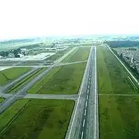
|
aeroway=ref=06/24
|
See Munich International Airport for a reference.
See also
aeroway=stopway– for paved areas beyond the edge of the runway usable in case of an aborted take-off.aeroway=highway_strip– for an emergency strip on a roadway, usually military in nature.aeroway=taxiway– for a taxiway used by aircraft to access runways from aircraft parking areas at an aerodrome.aeroway=helipad– A landing area or platform designed for helicopters.aeroway=launchpad– A launchpad or landing pad for spacecraft.aeroway=aircraft_crossing– for a point where a runway intersects with a railway or highway.aeroway=model_runway- Take-off and landing runway for model aircraft
External links
| ||||||||||||||||||||||||||||||||||||||||||||||||||