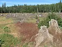
Tag:man_made=clearcut
 |
| Description |
|---|
| An area where all trees have been uniformly cut down. |
| Group: man made |
| Used on these elements |
| Useful combination |
| See also |
| Status: in use |
| Tools for this tag |
|
The tag man_made= is used to map a Clearcut, a former landuse=forest or natural=wood area where all or almost all trees have been uniformly cut down.
How to map
Create an area and tag it man_made=.
If there is a surrounding landuse=forest or natural=wood area, edit the woodland area or create a multipolygon to exclude the clearcut from the area of the woodland or forest.
If there is vegetation present, add a suitable tag such as natural=scrub for bushes, shrubs and very small trees (transitional scrub) or landuse=meadow for grasses and herbs (transitional meadow). See vegetation for more options.
Rendering
- Rendered as a pattern of stumps by OsmAnd.
- Not rendered by OpenStreetMap Carto, the style used on the standard map layer. See https://github.com/gravitystorm/openstreetmap-carto/issues/4159
See also
- Vegetation
landuse=forestlanduse=logging- a more common tag, but not as specificman_made=cutline- a srraight line cut into a forest- Clearcutting on Wikipedia