Tag:natural=scrub
 |
| Description |
|---|
| Uncultivated land covered with shrubs, bushes or stunted trees. |
| Rendering in OSM Carto |
|
| Group: natural |
| Used on these elements |
| Useful combination |
|
| See also |
| Status: de facto |
| Tools for this tag |
|
The tag natural= is used to tag areas of uncultivated land covered with shrubs, bushes or stunted trees.
Scrub (shrubland, scrubland, brush) is a plant community characterized by vegetation dominated by shrubs (bushes and stunted trees), often also including grasses, herbs, and geophytes. It may be the mature vegetation type in a particular region and remain stable over time, or a transitional community that occurs temporarily as the result of a disturbance, such as fire.
In addition to use on natural habitats, natural= is often used to tag semi-natural and semi-developed areas, such as areas of uncultivated shrubs along highways, and scrub in abandoned pasture which is transitioning back to forest.
natural= is also used (or misused, depending on the point of view) for maintained, cultivated areas of landscaping or shrubbery[1], but this usage is considered controversial. An alternative is the newer natural=shrubbery which fills this niche, but which was rejected as a proposal in large part because, conversely, a significant number of mappers who voted against it felt that this natural= should be used for this use case as well. Thus there are, broadly speaking, two conflicting standpoints for mapping cultivated shrubbery. For an in-depth explanation of this controversy, see the summary drafted in the aftermath of the two failed shrubbery proposals.
Tagging
natural= applies to areas. Using a node instead is acceptable, but only as a temporary measure, since it does not reveal extent of the vegetation.
Additional tags
name=*– name of the site, where available.leaf_type=broadleaved/needleleaved/mixed– describes the type of leaves.leaf_cycle=deciduous/evergreen/mixed– describes the phenology of leaves.
Mapping caveats
This tag should not be used for:
- Areas dominated by low-growing dwarf scrubs – use
natural=heathinstead. - Open woodlands with full grown trees with significant gaps between them – depending on tree density use
natural=woodor map what grows in between the trees. - Cultivated scrub plantations – depending on the purpose these might qualify as
landuse=orchard,landuse=farmlandorleisure=garden. - Hedges mapped as an area and beds of planted shrubs, that are manicured or otherwise actively maintained. There is work in progress to develop a fitting scheme for these, see
natural=shrubbery.
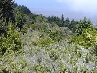
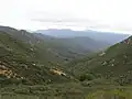
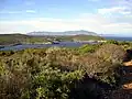
Examples
.jpg)
.jpg)
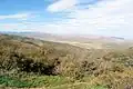
_Madeira.jpg)
Notes
The widely-used Anderson (1976) classification system has detailed descriptions of scrub. Particular attention should be paid to these classifications:
- 3 Rangeland
- 31 Herbaceous Rangeland
- 32 Shrub and Brush Rangeland
- 33 Mixed Rangeland
Corresponding landcover types in National Landcover Database (NLCD2006) and National Landcover Database (NLCD2011) are modified from the Anderson system:
- 5 Shrubland
- 51 Dwarf Scrub - (Alaska only) areas dominated by shrubs less than 20 centimeters (0.66 feet) tall with shrub canopy typically greater than 20% of total vegetation. This type is often co-associated with grasses, sedges, herbs, and non-vascular vegetation. See
natural=heath - 52 Shrub/Scrub - areas dominated by shrubs; less than 5 meters (16.4 feet) tall with shrub canopy typically greater than 20% of total vegetation. This class includes true shrubs, young trees in an early successional stage or trees stunted from environmental conditions.
- 51 Dwarf Scrub - (Alaska only) areas dominated by shrubs less than 20 centimeters (0.66 feet) tall with shrub canopy typically greater than 20% of total vegetation. This type is often co-associated with grasses, sedges, herbs, and non-vascular vegetation. See
Herbaceous, sedge, lichen, moss and wetlands (woody or herbaceous) are better tagged as features other than 'scrub'.
See also
leaf_type=*andleaf_cycle=*- Vegetation
natural=shrubfor standalone plantsnatural=heathfor dwarf scrub and healthlandnatural=shrubberyfor an area of shrubbery that is actively maintained or pruned by humans. A slightly wilder look is also possible.landuse=shrubsfor an area of cultivated shrubs
Common tagging mistakes
| ||||||||||||||||||||||||||||||||
- ↑
Examples of
natural=used in landscaped areas:- https://osm.org/#map=18/51.97910/5.66844 - The Netherlands
- https://osm.org/#map=18/52.51886/13.42195 - Berlin, Germany
- https://osm.org/#map=19/39.10163/-94.58035 - Kansas City, USA
- https://osm.org/#map=18/-23.53937/-46.67479 - São Paulo, Brazil