Tag:natural=heath
 |
| Description |
|---|
| A dwarf-shrub habitat, characterised by open, low growing woody vegetation, often dominated by plants of the Ericaceae. |
| Rendering in OSM Carto |

|
| Group: natural |
| Used on these elements |
| Useful combination |
| See also |
| Status: de facto |
| Tools for this tag |
|
The tag natural= is used to map areas of heath or heathland: a dwarf-shrub habitat, characterized by open, low-growing woody vegetation, often dominated by plants of the Ericaceae (Heather). The tag natural= can be applied to any similar habitat worldwide.[1]
How to map
Draw an area and add natural=.
Mapping caveats
This tag should not be used for:
- parks which happen to be named "something heath" (e.g., "Hampstead Heath"; quite common in England). A park should be tagged
leisure=park,leisure=nature_reserveorboundary=protected_areaas appropriate, even if it has "heath" in the name. Only if it is genuinely a heath fitting the description above (and not primarily regarded as a normal public park) then use this tag. - areas dominated by taller shrubs – use
natural=scrubinstead. - areas primarily covered by herbaceous (non-woody) plants like grasses – use
natural=grasslandorlanduse=meadow, if used for grazing, instead.
Examples
Here are various examples from different ecosystems – what can be seen in the foreground in those can commonly be mapped as natural=.
-
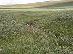 Subarctic ground willow (Salix brachycarpa), northern Finland
 -
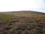 Heather at Achadh na Gaodha in Scottish Highlands
 -
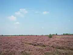
 Heath at Bredfjäll near Göteborg, Sweden
 -
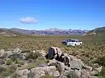 Sagebrush steppe of Río Negro Province, Argentina
 -
 Sagebrush steppe in Nevada, U.S.
 -
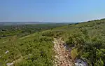 Garrigue of Southern France
 -
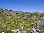 Phrygana in central Crete, Greece
See also
Possible tagging mistakes
Notes
External links
- See Heath on Wikipedia
| ||||||||||||||||||||||||||||||||