Tag:tourism=viewpoint
 |
| Description |
|---|
| A place worth visiting, often high, with a good view of surrounding countryside or notable buildings. |
| Rendering in OSM Carto |
| Group: tourism |
| Used on these elements |
| Useful combination |
| Status: de facto |
| Tools for this tag |
|
A place where tourists, visitors, hikers might like to visit and take photographs. A place, often high, with a good view of surrounding countryside or notable buildings. Sometimes called a vista point or scenic area/point, lookout or overlook.
Some are identified by signs, many more can be identified from local knowledge or from your own visit and judgement.
This tag identifies a good view. Interesting objects or buildings themselves should rather be tagged with an appropriate value of tourism=*.
How to map
Set a node ![]() at the viewpoint and add
at the viewpoint and add tourism=.
Direction of view

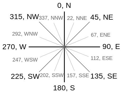
The direction of the view may be described by the direction=* tag, either by giving the main direction or the left and right limits (in this order).
direction=W |
View roughly to the west |
direction=S-W |
View from the south to the west |
direction=330-30 |
Viewing angle of 60 degrees around the north |
direction=70-110;250-290 |
Limited view to the east and west, no view to the north and south |
direction=0-360 |
Panorama view |
A map with showing the direction=*-Tag.
Examples
tourism=name=Beachy Headdirection=90-260description=Views of the English Channel, France can be seen on a clear day
tourism=man_made=towertower:type=observationname=Panorama Tower
tourism=natural=peakele=1489name=Gęsia Szyja
Rendering
- On the OpenStreetMap standard layer as a viewpoint icon with name if set.
- On OpenTopoMap as a viewpoint icon with correct direction(s).
- On osmtools for debugging the direction value.
See also
information=map+map_type=toposcope(board indicating the direction to notable landscape features which can be seen from that point)amenity=binoculars(pair of binoculars fixed in place on a pole)- Overlook on Wikipedia