Ko:Key:bus_bay
 |
| 설명 |
|---|
| 승객 승하차를 위해 차로 바깥에 만들어진 버스 구역 |
| 그룹: 도로 |
| 해당 요소의 사용 |
| 의존하는 태그 |
|
|
| 같이 보기 |
| 상태:승인 |
| 이 태그를 위한 도구 |
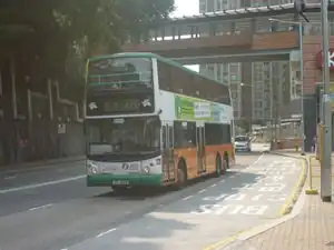
=* 키는 승객 승하차를 위한 버스 정차 구역의 존재를 나타내는 데 사용할 수 있습니다.
버스 정차 구역은 반드시 차로 바깥에 존재하고 물리적으로 분리되어 있지 않아야 합니다. 버스 정차 구역에 버스 정류장이 존재하는지의 여부는 상관 없습니다. 도로 변에 승객 승하차를 위한 버스 정차 구역으로 여겨지는 것이 존재하는지가 유일한 판단 기준입니다.
승하차 장소가 주 도로와 물리적으로 분리되어 있는 경우, highway=service 태그를 부여하고, 그 highway=service 도로변에 버스 구역이 존재하는 것이 아니라면 이 태그를 사용하지 마십시오.
Usage
To provide information about bus bays, add the =* tag to the highway=* way representing the street.
The values left and right depend on the direction in which the way is drawn in OpenStreetMap. A value of left means the left-hand side of the road when looking in forward direction, while right means the right-hand side. See Forward & backward, left & right for further explanation about directions and sides.
If the boarding place is physically separated from the street please use a separate way (e.g. highway=service).
Additional tags
Additional tags can be added by using the bus_bay: prefix, in combination with the :left/right/both suffix (becoming an infix here). For example:
Values
| Value | Description |
|---|---|
both
|
Both sides of the street have bus bays. |
right
|
One bus bay on the right side of the way representing the street. |
left
|
One bus bay on the left side of the way representing the street. |
See also
- Proposed_features/bus bay - approved proposal for this key
highway=emergency_bay- emergency bay on a highwayhighway=passing_place- A passing place on a single track road.public_transport=stop_positionhighway=bus_stop- Bus lanes
| ||||||||||||||||||||||||||||||
| ||||||||||||||||||||||||||||||||||||||||||||||||||