Tag:natural=sand
 |
| Description |
|---|
| An area covered by sand with no or very little vegetation. |
| Rendering in OSM Carto |

|
| Group: natural |
| Used on these elements |
| See also |
| Status: de facto |
| Tools for this tag |
|
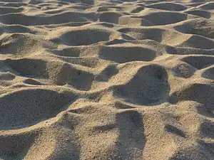
An area covered by loose ![]() sand with no or very little vegetation. Sand is usually understood to be fine grained loose rock material with grain sizes between 0.0625 mm and 2 mm. In nature, sand occurs mostly as either wind blown deposits (sand deserts, dunes) or deposited by water on beaches or in form of sandbanks in the sea or in rivers.
sand with no or very little vegetation. Sand is usually understood to be fine grained loose rock material with grain sizes between 0.0625 mm and 2 mm. In nature, sand occurs mostly as either wind blown deposits (sand deserts, dunes) or deposited by water on beaches or in form of sandbanks in the sea or in rivers.
How to map
Draw an area ![]() and add
and add natural=.
Use in combination tidal=yes to explain the foreshore like you do with natural=bare_rock
Mapping caveats
This tag should not be used for:
- beaches, i.e. stretches of sand at the coast formed by wave action from the ocean - use
natural=beach+surface=sandinstead. - flat areas with a muddy surface that are water covered at high tide but exposed at low tide - use
natural=wetland+wetland=tidalflatinstead. - bare ground areas with a significant fraction of finer (silt, clay) or coarser material (gravel, shingle) - for some of these, other tags exist (
natural=shinglefor example) - sandbanks under water at some times - use
natural=shoalinstead. - solidified sand, i.e. sandstone - use
natural=bare_rockinstead. - coarse mapping of larger non-vegetated areas, i.e. deserts - use
natural=desertinstead. - individual static dunes in a larger sand covered area - use
natural=duneinstead. - areas of mobile dunes that shift with the wind, i.e. an erg - use
landform=dune_systeminstead. - the infields of baseball or softball fields (a form of tagging for the renderer) - use
surface=dirtinstead.
If used for artificial sand areas like golf courses make sure to apply the appropriate tags indicating the purpose (like golf=bunker).
See also
| ||||||||||||||||||||||||||||||||