Zh-hans:Bicycle

|
| 说明 |
| Bicycle and cycleway features |
| 组 |
|
Bicycles |
| 标签 |
|
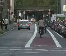
此页面列出了如何在OSM中添加和标记自行车和自行车道相关数据的一些可能选项。拥有高质量的自行车道数据可以让路线软件选择最适合骑自行车的方式。
自行车特征
OSM 区分自行车车道(lanes)和自行车专用道(tracks)。自行车车道位于道路内,而自行车专用道则与道路 (非道路上) 分隔。专用道通常由路缘、停车场、草地边缘、树木等与道路分开。
有两种方法可以对自行车专用道(cycle tracks)进行建模。一种可行的方法是沿着道路绘制单独的道路,标记为highway=cycleway。另一种是在现有道路上添加一个cycleway=track标签。这两种方法各有优缺点。显然,单独标记的自行车道通常可以捕获更多细节;而向现有车道添加单个标签所需的时间要少得多,而且在许多情况下也可以同样准确。这两种方法今天都在使用,并且关于何时更喜欢哪种方法存在讨论。
下表包含许多示例和图片,适用于右舵驾驶国家。
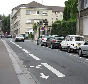
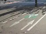
双向道路中的自行车道线
在道路的一部分上标记的车道,指定供骑车人使用。
| Ref | Context | Photo | OSM | Description |
|---|---|---|---|---|
| L1a | 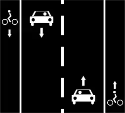 |
|
 |
道路左右两侧的自行车道。
Way A: or Way A: or Way A: |
| L1b |
 |
|
|
道路右侧的双向自行车道。
Way A: or Way A: |
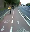
| L2 | 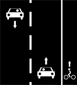 |
|
只有道路右侧有的单向自行车道。
Way A: (nb: bikes can use the traffic lane on the left side) |
单向道路上的自行车道线
| Ref | Context | Photo | OSM | Description | Example |
|---|---|---|---|---|---|
| M1 |
 |
|
|
自行车道在机动车单行道的左右两侧。
Way A: 或 Way A: |
370646853 |
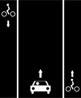
| M2a | 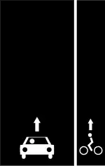 |
|
|
单行机动车道右侧有同向的自行车道。
Way A: 或 |
|
| M2b |  |
|
单行机动车道左侧有同向的自行车道。
Way A: 或 |
cycleway:left=lane N53度16分40.58秒, W9度04分17.62秒 | |
| M2c | 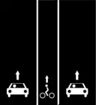 |
|
单向自行车道在行车道之间,方向上与单向道路相同。
Way A: |
||
| M2d | 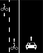 |
|
单向道路左侧的双向自行车道。
Way A:
|
619210833 | |
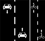
| M3a | 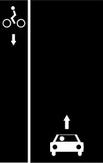 |
|
|
Oneway contraflow cycle lane on left side and opposite direction of the oneway road. Cyclists in one direction use lane together with other vehicles, in opposite one they have a dedicated lane.
Way A: |
132400917 |
| M3b |  |
|
Oneway contraflow cycle lane on right side and opposite direction of the oneway road. Cyclists in one direction use lane together with other vehicles, in opposite one they have a dedicated lane.
Way A: |
||
| M4 | 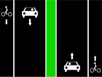 |
 |
单向自行车道位于分隔的单向道路右侧。
Way A: 与M2a相同 Way B: 与M2a相同 |
||
|
Alternative tagging for less accurate traces / aerials.
Way A: same as L1a |
||||
| M5 |  |
|
Oneway cycle lane on right side of a separated oneway road.
Way A: same as M2a |
||
|
Alternative tagging for less accurate traces / aerials.
Way A: same as L2 |
自行车专用道(tracks)
道路专用于单独通行权上的骑自行车者。
| 编号 | 内容 | 图片 | OSM | 描述 |
|---|---|---|---|---|
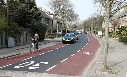
| T1 | 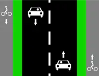 |

|
 |
道路左右两侧的自行车专用道(非机动车专用辅路)
Way A: |
|
(单路径替代解决方案,在轨道位置未知时也很有用) | |||
| T2 | 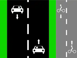 |
|
 |
道路右侧的双向自行车道。
Way A: |
|
(单路径解决方案,在轨道位置未知时也很有用)
Way A: | |||
| T3 | 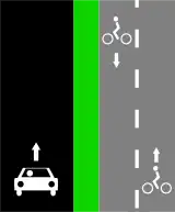 |
|
单向公路右侧的双向自行车道。
Way A: | |
|
(单路径解决方案,在轨道位置未知时也很有用)
Way A: | |||
| T4 | 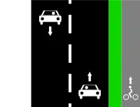 |
|
Oneway cycle track on right side of the road.
Way A: | |
|
(单路径解决方案,在轨道位置未知时也很有用)
Way A: (nb: bikes can use the traffic lane on the left side) |

混合类型
| 编号 | 内容 | 图片 | OSM | 描述 |
|---|---|---|---|---|
| S1 | 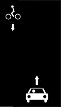 |
|
Cycling opposite to the oneway car traffic without dedicated lane/track (in some countries only).
Way A: | |
| S2 | 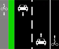 |
 |
Cycle track on left side and cycle lane on right side of the road.
Way A: | |
|
Way A: highway=*[1] + cycleway:left=track + cycleway:right=lane
| |||
| S3 | 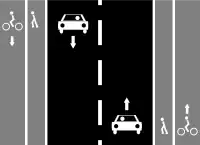 |
|
If sidewalks are mapped as a tag on the main highway: | |
|
Cycle tracks on left and right sides of the road and sidewalks.
If sidewalks are mapped as a tag on the main highway: Way A: | |||
| If sidewalks are mapped as separate ways:
Way A: Way B: Way C: | ||||
If sidewalks are mapped as separate ways without highway=path:
Way A: Way B: Way C: | ||||
| S4 | 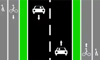 |
|
Easiest
Way A: | |
|
Cycle tracks on left and right sides of the road and the sidewalks/footways.
Way A: Way B: Way C: | |||
 |
Alternative solution with 5 ways in OSM:
Note that this variant is controversial as there is no physical separation between the cycleway and the footway. Use another variant if possible. Way A: Way B: | |||
| S5 |  |
 |
 |
Tag one shared line with:
Additionally for more detail specify individual surfaces by:
For example if like in image to the left, use:
|
 |
Tag it as two separate ways:
Note that this variant is controversial as there is no physical separation between the two ways. Use another variant if possible. Way A: | |||
| S6 | 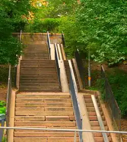 |
|
Steps with bicycle ramps can be tagged see ramp=*, possible bicycle friendly value can be:
| |
| S7 | |
Way designated for both cyclists and pedestrians, without separate spaces. Such combined footway+cycleway can be standalone or a sidewalk next to a road (in such case also footway=sidewalk is applicable)
| ||
| S8 | |
Footway not designated as a cycleway but where cycling is legal (for example in a park where rules allow this) |
自行车道和公共汽车/出租车专用道
| Ref | Context | Photo | OSM | Description |
|---|---|---|---|---|
| B1 | 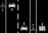 |
|
Cycle lanes on left and right sides of the road with a bus/taxi only lane.
Proposal (no consensus): Using the suffix for Lanes: Note: the suffix | |
| B2 | 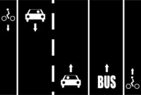 |
|
Cycle lanes on left and right sides of the road after a bus/taxi only lane in right side.
Proposal (no consensus): Way A: | |
| B3 | 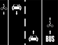 |
|
Cycle lane on left side of the road and a shared cycle lane with a bus/taxi lane in right side.
Way A: | |
| B4 | 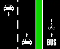 |
|
Cycle track shared with a bus/taxi track in right side of the road.
Proposal (no consensus): Way A: Way B: | |
| B5 |  |
|
Cycle lane shared with a bus/taxi lane on right side of the road (in some countries only).
Proposal (no consensus): Way A: | |
| B6 | 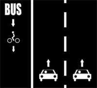 |
|
|
Cycle lane shared with a bus/taxi lane in opposite direction of the oneway road.
Proposal (no consensus): Way A: or Way A: |
All pictures are available in both .png and .svg files in the wiki repository (use .png when text is present).
- ↑ 1.00 1.01 1.02 1.03 1.04 1.05 1.06 1.07 1.08 1.09 1.10 1.11 1.12 1.13 1.14 1.15 1.16 1.17 1.18 1.19 1.20 1.21 1.22 1.23 1.24 1.25 1.26 1.27 1.28 1.29 1.30 1.31 1.32 1.33 1.34 1.35 1.36 1.37 1.38 1.39 1.40 1.41 any type of carriageways in the class
highway=*likeprimary/secondary/tertiary/unclassified/residential/etc.
Cycle streets 和 bicycle roads
Cycle streets是专为自行车设计的街道,机动车交通量低。目前,比利时、丹麦、德国、芬兰、荷兰、挪威、斯洛文尼亚和瑞士都有这种情况。在所有情况下,都有特定的交通标志,每个标志都有自己的含义。有关更多细节,请查看 cyclestreet=* wiki 页面。
这一概念与 bicycle_road=*密切相关,而后者只存在于德国。
添加 cyclestreet=yes, 不要改变 highway=*.
步行街
highway=pedestrian + (如果需要) bicycle=yes
越野和户外情况
在城市和人口稠密地区之外,当道路也被大型机动车(农业、林业、应急车辆……)使用时,大多数自行车道都是使用highway=track绘制的,而当道路不适合机动车(而是行人、马……)时,则使用highway=path绘制。虽然在世界上大多数地区,这两种情况都意味着bicycle=yes,但自行车导航程序很难将其建议为路线,因为各种条件(路面、坡度等)可能使它们不适合某些或所有类型的自行车。
应使用一些额外的标签来表明此类方式对自行车的适用性:
surface=*smoothness=*tracktype=*mtb:scale=*incline=*
另见 Mountain biking.
公路自行车(自行车友好型街道)
考虑使用以下键值对来指示自行车友好型街道。这些标签是客观的,可用于检测道路对骑行人友好的程度。
| 键(Key) | 值(Value) | 目的 |
|---|---|---|
maxspeed
|
限速值
|
限速较低的道路往往更少被大量机动车塞满 |
source:maxspeed
|
country_code:rural/country_code:urban/sign/…
|
始终标记最大速度限制的来源! |
surface=*
|
对于骑自行车的人来说,surface=asphalt 和surface=sand/surface=grass_paver/surface=unhewn_cobblestone之间存在非常显著的差异,这种差异要比比行人或汽车大。平滑度和车道类型质量标记是指定道路或路径表面质量的另外两种方法。
| |
traffic_calming=*
|
交通减速措施(减速带等)是限制机动车速度和使街道对骑自行车的人更安全的好方法。 | |
lanes=*
|
组成道路的标记车道总数
|
只有单个车道宽的低限速路段往往是低骑行压力路线(但可能会增加想要快速骑行的自行车手的压力) |
width
|
width of road in metres
|
指示宽阔的单车道道路 |
shoulder
|
no/yes/left/right/both
|
指示路肩的存在 |
cycleway
|
asl
|
高级停车线,在北美也被称为自行车箱 (bike boxes) |
自行车通行限制
| 键(Key) | 值(Value) | 何时使用 |
|---|---|---|
bicycle
|
yes
|
允许骑自行车的道路,指默认可通行 (例如,允许骑自行车的高速公路,这种情况在北美西部地区经常可以看到) |
bicycle
|
designated
|
当一条道路被特别指定 (通常由政府) 用于自行车使用时 |
bicycle
|
use_sidepath
|
由于有平行的强制自行车道,法律上不鼓励在主干道上骑行。请咨询当地法律。 |
bicycle
|
optional_sidepath
|
在主干道上骑行是合法的,但存在一条平行 (可选) 的自行车道。 |
bicycle
|
no
|
在不允许使用自行车的地方,请确保标明这一标签。请注意,可能仍然允许携带或推动自行车[1][2]。 |
bicycle
|
permissive
|
自行车没有法律规定的通行权,但土地所有者表示允许自行车通行。 |
bicycle
|
destination
|
自行车拥有合法的通行权,但前提是它们的目的地在该街道或区域内。 |
bicycle
|
dismount
|
在指示的自行车道短路段上禁止骑行,但允许步行推车(下车后推自行车)。 |
oneway:bicycle
|
yes/no
|
使用 oneway:bicycle=*来识别自行车单行道规则与一般单行道限制不同的道路。如果存在逆向车道,请参见上文参考M3a和M3b。如果自行车是唯一允许通行的车辆,则应使用更简单的oneway=* 标记。
|
See also for the default restrictions by highway type (and country-specific rules).
另请参阅OSM标签中的路径/通行限制,了解按公路类型(和特定国家/地区的规则)划分的默认限制。
All values: access=*.
For restrictions on speed pedelecs and electric bicycles, see the corresponding wiki pages.
Routes
Individual sections of road/street/path may collectively form an overall route with official signage.
These should be represented by creating a Relation, as follows:
plus the type of network:
network=lcn– local cycle network routesnetwork=rcn– regional cycle network routesnetwork=ncn– national cycle network routes
Only official routes, i.e. those signed on-street and/or published on maps by a local authority, should be entered into OSM. Informal recommendations, such as suggested routes published on general websites, do not form official infrastructure, and as such are not objective.
The use of lcn=* / rcn=* / ncn=* on a per-Way basis is deprecated and should no longer be used.
与其他道路使用者分开
Where a path is shared-use, i.e. for use by both cyclists and pedestrians, if the path is split, e.g. by a white line, the segregated=* tag should be used:
segregated=yes
|
Cyclists and pedestrians are separated, e.g. with a white line. |
segregated=no
|
No separation between cyclists and pedestrians. |
Note that the segregation tag has nothing to do with segregation with motor vehicles. For that, use the separation tag:
Separation from motor vehicles
Where a cycle track/lane is within a road and separated from other vehicles, e.g. protected (segregated) bike lanes, this should be specified using the new separation=* tag.
This enables specifying:
- The type of separation
- Which side of the cycleway the separation is on
separation=*
|
Used when the cycleway is mapped as a separate line (but is still built within the roadspace). |
cycleway:separation=*
|
Used when the cycleway is mapped as an attribute of the road line. |
障碍物
自行车基础设施可能包含各种障碍物,如护柱、障碍物、大门和非齐平路缘石。
因为它们会导致迟滞,甚至完全阻止较大车轮的用户使用道路,所以绘制这些障碍物的地图非常重要。
| Tag | Description |
|---|---|
barrier=cycle_barrier
|
For mapping chicanes. The maximum available physical width, or individual spacing/opening/overlap widths, can be specified. |
barrier=bollard
|
For bollard(s) within a path. |
barrier=gate
|
For a gate. |
kerb=no
|
For when there is no kerb between sections of path/road, resulting in the cyclist having to stop/dismount. By constrast, kerb=flush can be used to declare explicitly that the kerb, i.e. no barrier.
|
highway=steps
|
Steps obviously require cyclists to dismount. If there is a wheeling channel/ramp, add ramp:bicycle=yes. See example above.
|
自行车停车区
自行车停车对自行车使用者的安全至关重要。设施可以是独立的架子、可上锁的单元,甚至是大型的专用自行车停车场建筑。
| Key | Value |
|---|---|
amenity
|
bicycle_parking
|
You should also ideally include the type, capacity (number of cycles) and whether covered. Full details are on the bicycle_parking page.
设施
如果有出租/租用自行车的设施,请使用:
| Key | Value |
|---|---|
amenity
|
bicycle_rental
|
service:bicycle:rental
|
yes
|
销售自行车和设备的商店:
| Key | Value |
|---|---|
shop
|
bicycle
|
service:bicycle:retail
|
yes
|
用于给自行车轮胎充气的气泵:
| Key | Value |
|---|---|
amenity
|
compressed_air
|
compressed_air
|
yes
|
service:bicycle:pump
|
|
对于自己动手(DIY)的自助维修站:
| Key | Value |
|---|---|
amenity
|
bicycle_repair_station
|
service:bicycle:diy
|
yes
|
对于出售内胎的自动售货机:
| Key | Value |
|---|---|
vending
|
bicycle_tube
|
对于街道设施或自行车骑行者设备,旨在使在特别是交通灯处等待更舒适(称为“自行车脚踏板”、“斜轨”或“自行车扶手”):
| Key | Value |
|---|---|
highway
|
cyclist_waiting_aid
|
自行车柜台
- Bicycle counters (with an optional display, i.e. totem/barometer with clock)
自行车俱乐部和协会
使用OSM的在线服务
制图/图层瓦片(tiles)
- OpenCycleMap – 为骑行的人设计的渲染地图
- CyclOSM – 为每个骑自行车的人提供免费渲染项目
交互地图
- Bicycle tags map – 带有自行车相关OSM标签的滑动地图
- Waymarked Trails – 显示自行车和山地自行车路线的地图
- flosm cycle map – 带有路线的自行车地图
- CicloMapa – 巴西城市的自行车地图、POI和指标
- Amenagements-cyclables 提供法国当地的统计数据和一个全球基础地图,清晰强调了自行车道的广泛定义
骑行导航
- BRouter – 在移动或在线上为不同类型的自行车手制定路线(全球范围)
- Geovelo – routing for cyclists with different profiles, on mobile or online (Europe and North America)
- CycleStreets – routing for cyclists (UK, much of Europe, various cities around the world)
- BBBike @ World – a cycle route planner for more than 200 cities worldwide
- cycle.travel – routing for cyclists (UK, Europe, North America, Australia+NZ)
- GraphHopper – routing for cyclists (world-wide)
- Komoot – routing for cycling and hiking (world-wide)
- Naviki – routing for cyclists (world-wide)
- Trip4YouMaps [1] – routing, navigation & tracking for cycling and hiking (world-wide)
- Traili – routing for cyclists (world-wide)
参见
sport=cyclingcycleway:lane=*用于区分建议自行车道和专用自行车道- Proposal:Key:is sidepath – to indicate whether a cycle way runs in parallel along a street, making it adjoining or runs separated and thus detached from the road
- DE:Bicycle(de) – big "portal" related to bicycle mapping (in German)
- Mountainbike – portal for mountainbiking
- Tourism – cycling is a way for tourism